Along the Brittany Coast through Mont-Saint-Michel and Saint-Malo
Traveling to Brittany
Let's visit Mont-Saint-Michel and Saint-Malo, two historic sites along the north coast of Brittany in northern France. Mont-Saint-Michel is the second most visited site in France after Paris itself and the Île-de-France. It has been a significant ecclesiastical center and pilgrimage destination since the early 700s. The port city of Saint-Malo is also very popular with visitors. It was a shipping and pirate base in past centuries, and now is a busy ferry port connecting far northwestern France to Britain, Spain, and Ireland. This is a composite of three visits to the area. My first visit was in the autumn of 2001. Fear permeated the air, the French still used Francs, Northwest Airlines still existed, and they still flew DC-10 aircraft. My other visits here were in 2006 and 2010.
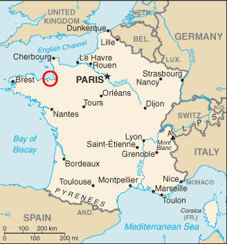
Saint-Malo and Mont-Saint-Michel are within the red circle on this map of France, along the northern coast of eastern Brittany.
Getting Started
I was writing and teaching courses for Learning Tree, a I.T. training company. They have a somewhat confusing name, as it sounds like a day-care center for children. Although, when teaching to some of the federal contractors making up the Military-Intel-Industrial Complex...
Anyway, in 2001 they had a contract to do some customized training in networking for EMC Corporation and they were looking to fill some one-week teaching contracts. Ethernet switches, Cisco routers, that sort of thing. They needed to run one course in London and one in Frankfurt, with a couple of weeks in between.
BudgetHotels in
France
I told them that I would do both courses and they would only have to buy one round-trip trans-Atlantic airline ticket, if they would pay for a handful of train tickets, a ferry ticket, and some really cheap hotel rooms as I went overland from London to Frankfurt. They didn't like the part about the lodging until I turned in my billing statement. They saw that what I called "cheap", even in Paris, was trivial compared to what they routinely spend on business-oriented high-end hotels. I think that my lodging for the entire overland route cost less than one night where they had me stay for a week near EMC's site outside Frankfurt. That hotel was a former spa up in the hills at Königstein im Taunus, built as an officer's retreat for Kaiser Wilhelm and now the Falkenstein Grand Kempinski hotel.
This was back in early October through early November of 2001, just a month after 9/11, so I flew out of the U.S. on a Northwest Airlines DC-10 only about 30% filled with nervous people. War news filled the air. Advance U.S. forces were deploying into Afghanistan, and the mysterious anthrax mailings were just starting within the U.S. Further terror attacks were expected to hit any day. Further terrorism did eventually happen, although it's been perpetrated by Dick Cheney and Fox "News" and their years of beating the Fear Drum.
From London through Winchester to France
The first week was a course in west London near the botanical institute of Kew Gardens. I finished that course and then took a train south to Winchester. A few of the pubs there did B&B but they were either full or rather expensive. I ended up at the youth hostel in the old mill straddling the stream running through the center of town. The mill was originally built in medieval times but it was "newly rebuilt" in the 1740s. Bunks were upstairs between the rafters. Cheap enough, under £10, although it was the old style where the outer doors are locked at 2300 and you have be out of the building from 1000 to 1700.
When I returned to Winchester in 2006, the hostel had closed. The TIC (a vital part of a British town — the Tourist Information Centre) recommended B&B in a private home for half the cost of upstairs at any of the few pubs doing B&B. It varies from one town to another, sometimes several pubs do B&B, sometimes none. The TIC sent me to the Sullivans at 29 Stockbridge Road, close to the train station. Only twice the cost of the hostel and far nicer.
An up-to-date guide book can be essential for transportation details. However, all of the guide book lines have drifted to cover more and more expensive accommodations. Lonely Planet used to be very clearly aimed at the budget traveler. Now they cover much more opulent lodgings. A few budget places are mentioned, but only as 10-20% or less of what they describe in any location. Buy a used Lonely Planet book from Amazon, getting something from the late 1990s or early 2000s at the latest. History is the same as it was back then, and the town maps will mostly be exactly the same. A lot of budget places are still in business in the same locations under the same names, but they get dropped when the guide books dedicate more and more space to luxury hotels.
There's plenty to see in Winchester, which is home to an enormous cathedral. While there, I bought a ferry ticket at a Thomas Cook office for an overnight ferry running from Portsmouth across the English Channel to Saint-Malo on the north Brittany coast in France.
Both Southampton and Portsmouth are major seaports which have almost grown together over the centuries. Southampton is the largest freight port on the Channel coast and the UK's fourth largest freight port overall. Luxury cruise ships call at Southampton. Portsmouth is a major Royal Navy base and home of the Royal Marine Commandos. Portsmouth also has heavy traffic in freighters and passenger ferries.
Portsmouth Continental Ferry Port has connections to the U.K. Channel Islands and to Caen, Cherbourg-Octeville, Saint-Malo, and Le Havre on the north coast of France, as well as longer routes to Spain.
Sailing from Portsmouth to Saint-Malo, southwest and then south around the Cotentin Peninsula, the ferry also passes the Channel Islands. Alderney is the northernmost. Then Guernsey with small nearby Herm and Sark (and even smaller named islets). Finally, Jersey.
The English call that body of water the English Channel, although to no one's surprise other countries have different names for it. The French call it La Manche.
I would be crossing it on the M/V Bretagne, a ferry owned by the French company Brittany Ferries. It can be a little confusing, with the French calling their peninsula Bretagne (like the ship) and that large island across the channel Grande-Bretagne, while we English speakers call them Brittany (like the shipping company) and Great Britain. Meanwhile, over 200,000 native speakers of the Breton language would say we're all wrong, it's Breizh and Breizh-Veur.
Anyway, the M/V Bretagne is a large vessel, 153 meters long and 24,534 gross tons, carrying up to 2,056 passengers and 580 vehicles. It was designed as a "cruise-ferry", offering cruise type facilities (bars with live bands, a casino room) while operating on a ferry route. All that needs a crew of 130, the ship's operational crew plus staff for the cruise-style features.
Traveling to Brittany
Crossing to Saint-Malo
I took the train down to Portsmouth in the late afternoon and walked from the train station to the ferry port. We boarded at 1945, and pulled away from the pier into the dark mist at 2030.
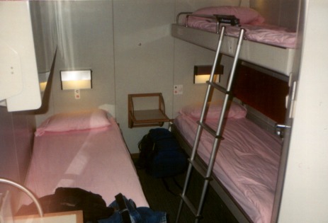
The route takes 10.5 hours with the Wärtsilä diesels pushing the ship at 21 knots cruise speed. Even on an overnight run like the one I took, they still draw lots of people into the cruise facilities. Some plan to stay up all night. I had spent a little more and got a night's sleep. For £48 I had a bunk in a shared cabin with its own head and shower. There were four bunks, one remained stowed against the bulkhead and only one of the other two was occupied. The cabin was very much like those on the ferries crossing the Gulf of Finland between Helsinki and Tallinn, Estonia.
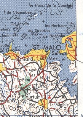
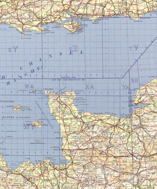
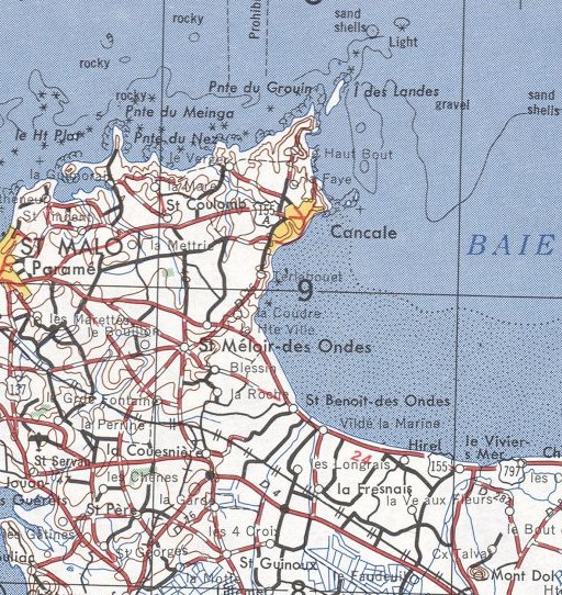
A fundamental law of cartography states that whatever you're looking for will fall across the borders of two maps. This first map is U.S. Army Corps of Engineers map NM 30-11 at 1:250,000 scale. Saint-Malo is cut in half by the east margin of the map.
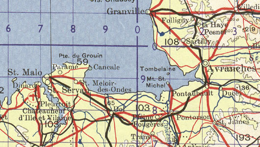
The second map, NM 30 at 1:1,000,000, keeps Saint-Malo intact. You can also see, in black, the rail line I will take from there through Dol-de-Bretagne to Pontorson.
A wake-up announcement comes over the loudspeakers when you're an hour out of port. I showered and headed out on deck. The clear sky was almost completely dark, with just a little light showing to the east.
We arrived at 0800 local time, which was an hour ahead of UK time. It was just starting to get light as we got off the ship. Sunrise didn't happen until 0830 here along the western tip of Europe near the end of Daylight Savings Time. Here started a week and a half of speaking nothing but French.
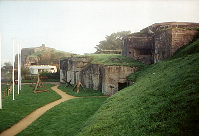
I didn't know if the place I hoped to stay would be open before sunrise, so I walked around the harbor. The pictures below show a damaged steel armored observation post overlooking the harbor from Fort de la Cité, a legacy of the Nazi occupation. In the first picture you can dimly see the ferry in the morning coastal fog.
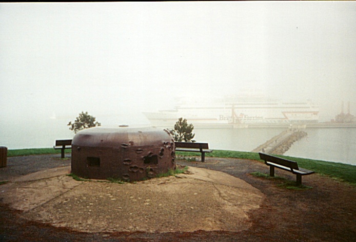
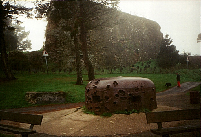
Large reinforced naval gun casemates were nearby. In front of them are some beach defense obstacles, placed here as part of the historical display at Fort de la Cité. All this was part of General Erwin Rommel's Atlantikwall or "Atlantic Wall", the coastal fortifications of German-occupied Europe in anticipation of an allied invasion. For more on Rommel's fortifications, see my visit to Utah Beach.

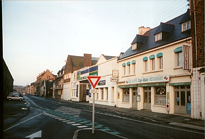
I walked back along the jetty beside the inner harbor to the Hotel Cap-Malo. Its restaurant-bar on the ground floor was open. Yes, they had a room with a double bed and a sink for 160 FF or just over $22.
They gave me two keys, one for the room itself and one to the outer door of the bar. They close the bar early in the off-season, and when I returned probablement it would be locked. Sure enough, when I returned that night the building was dark and shuttered as if unoccupied. No problem, I can let myself in and lock the outer door behind me. There were small dim lights behind the bar and in the hallway.
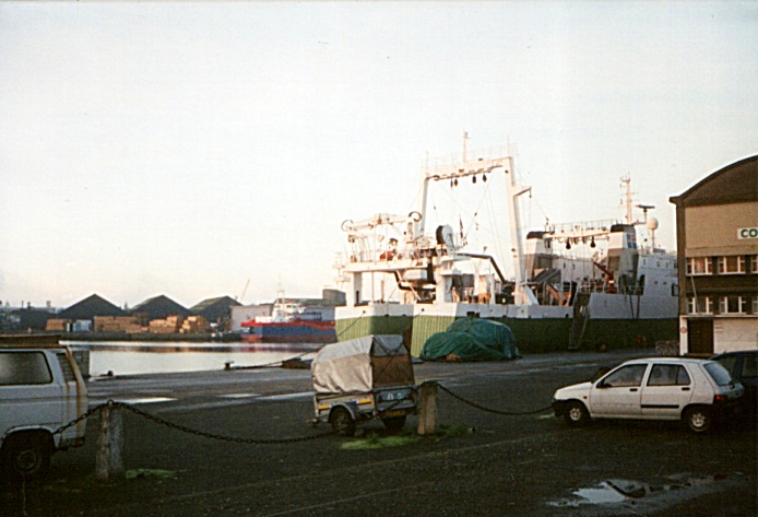
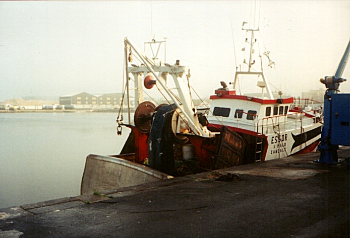
The large white and green fishing ship above and the small red and white one below were just across the quay from the Cap-Malo. Saint-Malo was a fishing center in the early 1800s, developing fishing operations across the Atlantic off the coast of Newfoundland.
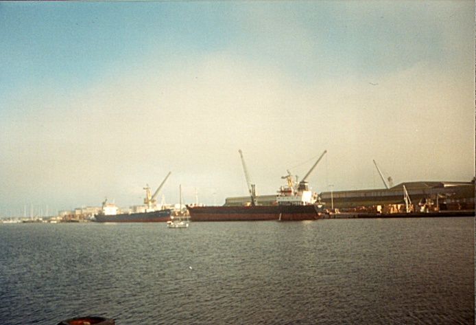
The commercial port of Saint-Malo moves some 2.2 million tons of freight every year, making it the third busiest freight port in Brittany and 15th busiest nationally. It can handle vessels up to 15,000 tons with maximum length of 150 meters and draft of 9 meters. The freight is mostly short distance container transport. The 1.4 million passengers per year, mainly to Britain and the Channel Islands, makes it the busiest ferry port in Brittany.
The Canal d'Ille et Rance was opened in 1832 after 30 years of construction, connecting the inland regional capital of Rennes to the Saint-Malo port. But the railroad joining Rennes to Saint-Malo opened in 1864, starting a significant drop in inland waterway traffic. Barge trade on that canal ended in 1960.
Aleth was the city of the maritime Gaulish people of Coriosolites. Today it's the site of Saint-Servan, the south side of Saint-Malo. The Romans fortified Aleth in the late 200s AD in a time of unrest in Gaul and especially along its northern coast. The marshy plain with its rocky outcropping Kanalch or Canalch, called Canalchius insulae by the Romans, remained unoccupied. That area would eventually become the walled city of Saint-Malo.
The Roman army withdrew in 420 and Aleth began suffering attacks from the north. In 507 a holy man named Aaron "retired from the temptations of the world" and built and occupied an oratory on the rock Canalch which he called the "Aaron Stone". Malo, from an area today in Wales, joined him in 538. He was also known as Maclou, Maclaw, and Maclovius. Malo died in 541, and the Aaron Stone became the Stone of Saint-Malo. The Normans, Norsemen living in today's Normandy, repeatedly attacked Aleth. The Diocese of Aleth was moved to the Rock of Saent-Mallou in the middle 1100s. It was known as Saint-Malou in the late 1200s, then Saint Malo in 1304. The territory was absorbed into the Duchy of Brittany, and then in 1493 it was formally annexed to the royal domain of France.
Jacques Cartier, a resident of Saint-Malo, famously "discovered" Canada by planting a cross in 1534 on the Gaspé Peninsula and claiming the land for Francis I. He later sailed up the Saint Laurence River and visited the sites of Quebec City and Montréal. His "discovery" was some ten years after Francis I had sent Giovanni da Verrazzano to explore the area between Florida and Newfoundland to look for a route to the Pacific Ocean and Asia. Meanwhile, back in 1506, King Manuel I of Portugal was taxing cod fisheries in Newfoundland waters. The Portuguese Crown claimed territorial rights based on John Cabot's visits in 1497 and 1498.
That was over 500 years after Bjarni Herjólfsson was blown off course in the summer of 985 or 986 and saw Canada, as described in the Grœnlendinga Saga. This led to landings by Liefr Eiríksson (or Leif Erikson) around 1001 and the establishment of the Norse settlement at L'Anse aux Meadows.
All of this must have come as a huge surprise to the native people who had been living in North America since around 16,500 years ago.
The city of Saint-Malo declared itself the independent Republic of Saint-Malo for 1590-1593. The corsairs, as pirates may euphemistically be known, established themselves. Saint-Malo was a city of pirates through the 1600s, harassing British shipping and sending expeditions around the world. The first colonists of the Falkland Islands came from Saint-Malo, leading to the French name Îles Malouines and in turn to the spanish name Islas Mavinas.
The VIII Corps of the 3rd U.S. Army under General George Patton was sent west to seize the port of Brest in August 1944 after the D-Day landings in early June. The Americans came under fire from German artillery near Saint-Malo and returned fire heavily. The Breton Resistance reported that there were only 70 men of the 5th AAA battery of Flak-Abteilung 912 in the old city. The U.S. offensive continued to shell the city for more than a week, and then 150 Liberator heavy bombers almost entirely destroyed the old city on Sunday, 14 August 1944. It was rebuilt according to the original plans over the period of 1948–1960.

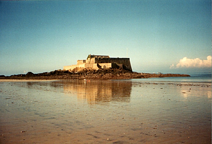

The tides are extreme here as the water surges in and out of the triangular bay formed by the Breton coast and the Cotentin Peninsula. The water level can vary by up to 14 meters, twice the normal range in the Atlantic. The waterline moves in and out by hundreds of meters. There are brief times during the day when you can walk out to l'Île du Grand Bé. François-René de Chateaubriand, the writer and diplomat, was born in Saint-Malo and is buried in the Fort National on l'Île du Grand Bé.
Thalassotherapy or the administration of sea-baths in various forms became a local specialty. This swimming pool is flooded by the ocean at high tide.
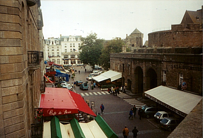
There are many restaurants in the walled old city, today a prominent tourist destination. Saint-Malo is famous for the Cancale oysters from that nearby town.
Be sure to try a pichête de cidre, a small stoneware pitcher of about 500 ml of the local hard cider. It's slightly carbonated and a little smokey.
Saint-Malo is fairly quiet in the evening in late October. By the time I returned to the Cap-Malo, the neighborhood was almost entirely dark. A few places were open along the shosée along the north-facing beach.
Brittany Coast East of Saint-Malo
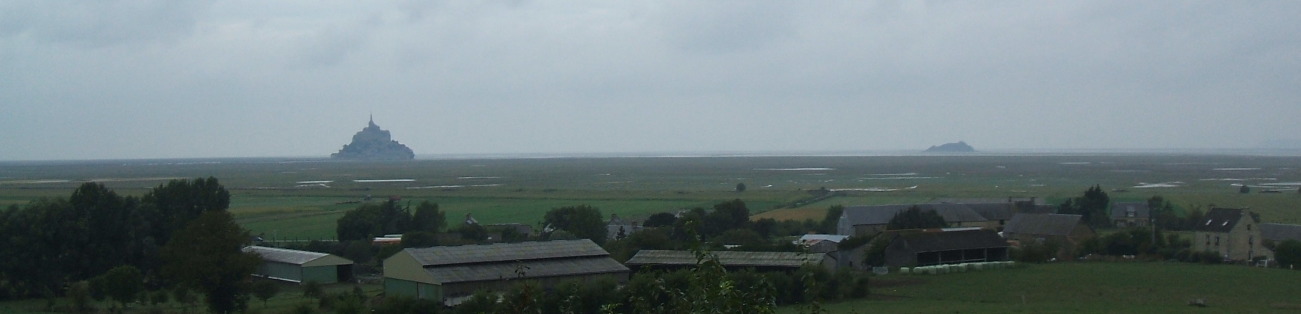
Now we jump to pictures from a visit in 2010. We had been in Normandy, visited Mont-Saint-Michel, and briefly passed through Saint-Malo before heading back east to Paris.
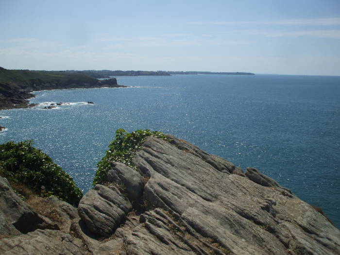
The pictures below are from the rugged point east of Saint-Malo, north of Cancale, out to Pointe du Grouin.

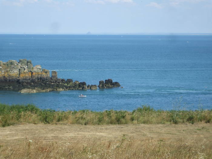
Mont-Saint-Michel is visible as a distant cone in the last picture above.