Street sign at the intersection of Haight and Ashbury in San Francisco, California.  The center of the hippie movement during the Summer of Love in 1967.

 San Francisco's Haight-Ashbury District 

The Summer of Love was the summer of 1967, a defining period of the 1960s when people collectively labeled as the hippies gathered in many cities across the U.S., Canada, and Europe.

Victorian houses in the Haight-Ashbury area of San Francisco.

San Francisco was the center of the hippie movement during the Summer of Love. Up to 100,000 people came to the movement's Ground Zero, the Haight-Ashbury neighborhood in San Francisco.

"The Haight" was filled with music, psychoactive drugs, sexual experimentation and political extremism. The area became closely associated with several significant bands and individual musicians including the Grateful Dead, Jefferson Airplane and Jimi Hendrix.

Haight Street runs straight east from the east end of Golden Gate Park and Stanyan Street. Ashbury Street is a north-south street crossing Haight about six blocks from its western end.

Meanwhile, many other cities like Detroit were filled with race riots and insurrections in what was also known as the Long, Hot Summer.

The term "Haight-Ashbury district" is generally used to describe an area bounded on its west by Golden Gate Park, on its north by Oak Street, on its east by Baker Street and the steep slopes of Buena Vista Park, and on its south by Frederick Street.

Locals call the district the Upper Haight, distinguishing it from the Lower Height or the Haight-Fillmore district.

William Lange was the first person to settle in the area, when he established a dairy farm in 1870. The area was nothing but a few isolated farms among large sand dunes until 1883. That year saw the completion of the Haight Street Cable Railroad, connecting the area to the busy Market Street line leading through downtown San Francisco.

Victorian houses in the Haight-Ashbury area of San Francisco.
  Enter a city
Check-in
Check-out
Rooms :
Child
Adult(s)

The area became an upper-middle-class residential area through the 1890s and early 1900s. Its location spared it from the enormous fires coupled with the great earthquake of 1906.

The depression hit the entire city hard through the 1930s, including the Upper Haight. Many of the families left for smaller and more affordable homes.

World War II and the associated naval construction and operations in the Bay Area brought a housing crunch. Many of the large multi-story Victorian homes were converted from single-family dwellings into apartments or boarding houses.

Many of the houses were left vacant after the end of the war, and the area declined through the 1950s. A public fight over a proposed freeway that would have run through the neighborhood lasted from the late 1950s until 1966. The threat of the freeway further dropped property values.

The neighborhood became a low-rent Bohemia through the 1960s and into the 1970s. The hippie subculture sprang up in Haight-Ashbury, and to a limited extent, still remains.

1:1,000,000 map of the Bay Area from 1959.

1:250,000 map, 1980, U.S. Geological Survey

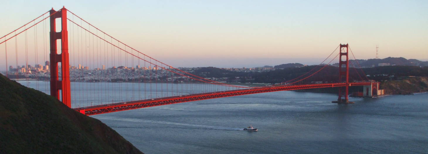
The Golden Gate is an opening 4,200 feet (or 1,280 meters) wide at its narrowest, connecting the large bay system to the Pacific Ocean. The Golden Gate Bridge has spanned it since its completion in 1937, when it was the longest suspension bridge in the world.

San Francisco Bay extends to the south about 30 miles (or 50 km) to the Silicon Valley area. San Pablo Bay is to the north, extending on inland as a large bay and eventually narrowing into the Sacramento and San Joaquin Rivers.
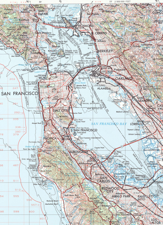
The area just north of the Golden Gate is not heavily settled due to the rugged topography, making for some great scenery and parks very close to a large city. Muir Woods and its stand of California Redwoods is just a short drive from the city.

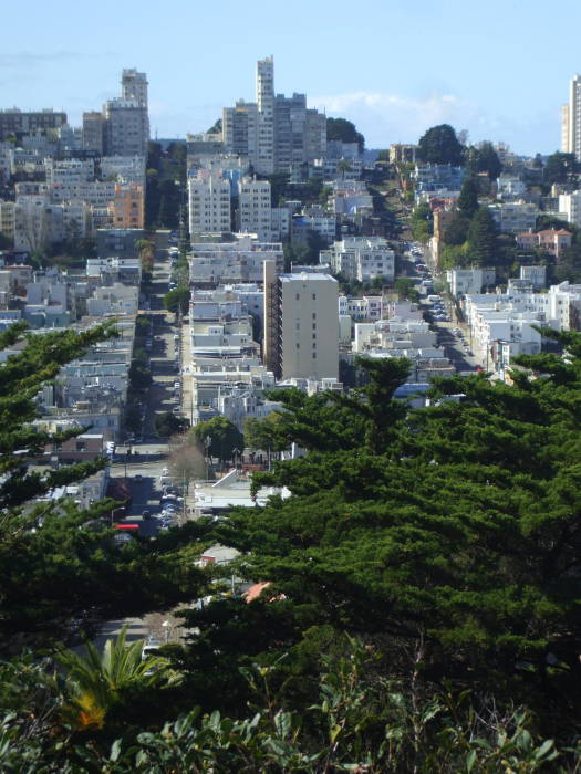
The city of San Francisco itself is famously hilly, much more so than most major cities. The topography has limited the city's growth, resulting in a densely settled area with sharp boundaries rather than the usual ever-growing sprawl.

Amtrak's passenger train service "to San Francisco" is really to the city of Oakland, across the bay. The trains arrive and depart at the Oakland station, buses connect to Amtrak's "station", really a bus station along the Embarcadero waterfront near one end of the San Francisco - Oakland Bay Bridge.

The airport is on a small shelf extending into the bay, with little opportunity for expansion beyond further fill to extend the runways.

Skate store.  Haight Street, between its west end at Golden Gate Park and Mission Street.

Let's start our walk down Haight Street.

We'll start at its west end, where it tees into Stanyan Street along the east end of Golden Gate Park.

Skates on Haight is near the west end of Haight, across from the famous Amoeba Music store.

Zona Rosa, a Mexican restaurant.  Haight Street, between its west end at Golden Gate Park and Mission Street.

We're crossing Shrader Street and continuing east along the south side of Haight.

Bus stop and movie theatre.  Haight Street, between its west end at Golden Gate Park and Mission Street.

The Haight Street Cable Railroad disappeared long ago. Today the Muni buses 71, 71L, and 7 connect Haight-Ashbury to Market Street and its busy streetcar lines. Muni bus 6 also runs to and from Market, although it turns off on Parnassus.

At Market Street you can walk south along Mission Street into the Mission District. Or, you can take a street car or one of several bus lines northeast along Market Street to the Embarcadero, the waterfront along San Francisco Bay.

Bus stop and movie theatre.  Haight Street, between its west end at Golden Gate Park and Mission Street.

Haight-Ashbury is no longer a counter-cultural place. Other than a few smoke shops and Himalayan-themed places, it's largely high-end boutiques and vintage clothing stores, hip restaurants, and fashionable cafes.

The San Francisco Chronicle's SFGate has a good guide to Haight-Ashbury with a comprehensive list of restaurants, cafes, shops, and more.

Colorful mural of a warrior woman on a mini-mart.  Haight Street, between its west end at Golden Gate Park and Mission Street.

Colorful murals decorate some buildings, like this one on the side of Frank's Liquors at the corner of Haight and Cole.

Restaurants and gift shops.  Haight Street, between its west end at Golden Gate Park and Mission Street.

We are approaching the crossing of Belvedere Street.

See the sign for a business named Cheap Thrills, named for the 1968 album by Big Brother and the Holding Company, with Janis Joplin.

Restaurants, bars, and music stores.  Haight Street, between its west end at Golden Gate Park and Mission Street.

Here are more Victorian buildings with rounded and segmented fronts.

The extend slightly over the sidewalk below, providing a little more interior space than the foundation outline.

Their angled windows provide more light and better views to either side.

Restaurants, bars, and music stores.  Haight Street, between its west end at Golden Gate Park and Mission Street.

We're crossing Clayton Street, we're just one block west of Ashbury.

The intersection of Haight and Ashbury.  Haight Street, between its west end at Golden Gate Park and Mission Street.

This is it, the intersection of Haight and Ashbury. We're looking at the northwest corner of the intersection, across it and on down the hill on Ashbury. That leads toward the panhandle of Golden Gate Park extending several blocks to the east of the main body of the park, parallel to Haight Street and forming the north edge of the Haight-Ashbury district.

Ben and Jerry's ice cream shop at the intersection of Haight and Ashbury.  Haight Street, between its west end at Golden Gate Park and Mission Street.

Here's proof that this is no longer a counter-cultural area: the northeast corner of the Haight-Ashbury intersection is home to a Ben and Jerry's ice cream shop.

At least it's not a Gap or a Benneton.

The intersection of Haight and Ashbury.  Haight Street, between its west end at Golden Gate Park and Mission Street.

Turning back to our original direction of travel, to the east, we continue across Ashbury on Haight.

Poster and smoke shops.  Haight Street, between its west end at Golden Gate Park and Mission Street.

The block between Ashbury and Masonic features a large pair of legs protruding from the second floor.

Magnolia brewpub at Haight and Mission.  Haight Street, between its west end at Golden Gate Park and Mission Street.

The Magnolia Pub and Brewery is on the northeast corner of Haight and Masonic.

The burlesque performer Patricia Donna Mallon (1940-1996) took the stage name of Magnolia Thunderpussy.

She also operated two restaurants. One of them was here, at 1398 Haight Street. One of her specialties was desserts created in erotic designs.

David McLean founded the Magnolia brewpub where her restaurant had been located, naming it after her. It's been a brewpub since 1997.

No, they didn't write that song about the burlesque performer. It's said to have been written about Bob Weir's long-time girlfriend, Frankie.

And here I had thought it was a reference to the Grateful Dead's song Sugar Magnolia....

The song was on their 1970 American Beauty album, and was the second most frequently played song in their concerts.

The brewpub does has a Grateful Dead vibe.

Building with Jimi Hendrix's apartment.  Haight Street, between its west end at Golden Gate Park and Mission Street. Building with Jimi Hendrix's apartment.  Haight Street, between its west end at Golden Gate Park and Mission Street.

Jimi Hendrix, one of the greatest electric guitar artists in history, lived at 1524 Haight Street for a while before his untimely death in 1970.

His apartment was above what is now the Ashbury Smoke Shop.

The neon in their window makes a bit of a purple haze.

The Grateful Dead in Haight-Ashbury

House occupied by the Grateful Dead, at #710 Ashbury, just above Haight.

The Grateful Dead lived in the house at #710 Ashbury Street, just a block and a half up the hill from Haight.

It's the purple house, just to the left of the streetlight pole in this picture.

The house was constructed in 1890 by the building contractors Cranston and Keenan. The Cranston of that firm was the grandfather of former U.S. Senator Alan Cranston. Cranston and Keenan built a large number of homes in the Upper Haight in the 1890s and 1900s. The homes sold for around $7,000, a considerable price then.

I read somewhere that Shakedown Street, their 1978 studio album, was named for Haight Street. But then I've also read that it's a term for the vendors' tent area at an outdoor music festival. Given that the album didn't come out until 1978, I would go with the second explanation.

At any rate, the band lived in this Victorian house during the Summer of Love. It has since been very nicely renovated.

House occupied by the Grateful Dead, at #710 Ashbury, just above Haight.

The Grateful Dead had formed in 1965, playing an eclectic combination of rock, jazz, folk, bluegrass, country, blues, and more.

Jerry Garcia and Phil Lesh had been brought together for a performance on The Midnight Special on KPFA-Berkeley in 1964.

The band formed in early 1965 from the remnants of a Palo Alto jug band, Mother McCree's Uptown Jug Champions. They initially called themselves The Warlocks, but then changed their name to The Grateful Dead at a performance on December 4, 1965, at one of Ken Kesey's Acid Tests in Palo Alto.

The charter members were: Jerry Garcia on banjo and guitar, Bob Weir on guitar, Ron "Pigpen" McKernan on organ, Phil Lesh on bass, and Bill Kreutzmann on drums.

House occupied by the Grateful Dead, at #710 Ashbury, just above Haight.

The lineup in the summer of 1967 would have still been the same.

Mickey Hart joined as a second percussionist in September of 1967, and Tom Constanten joined as a second keyboard player in November of 1968.

The Hell's Angels in Haight-Ashbury

House occupied by the Hell's Angels, at #719 Ashbury, just above Haight.

The Hell's Angels Motorcycle Club was based in a house at #719 Ashbury, just across the street from the Grateful Dead's house.

House occupied by the Hell's Angels, at #719 Ashbury, just above Haight.

Both Hunter S. Thompson's Hell's Angels: A Strange and Terrible Saga and Tom Wolfe's The Electric Kool-Aid Acid Test describe the Hell's Angels presence in this area in the late 1960s.

Thompson's book is pretty harrowing, as he describes how he seemed to have made genuine friends with a number of them but then was savagely beaten with no warning. Of the Angels he wrote:

The hard core, the outlaw elite, were the Hell's Angels... wearing the winged death's-head on the back of their sleeveless jackets and packing their "mamas" behind them on big "chopped hogs." They rode with a fine unwashed arrogance, secure in their reputation as the rottenest motorcycle gang in the whole history of Christendom.

And, regarding their mystique:

The streets of every city in America are filled with men who would pay all the money they could lay their hands on to be transformed, even for a day, into hairy, hard-fisted brutes who walk all over cops, extort drinks from terrified bartenders and roar out of town on big motorcycles after raping the banker's daughter.

There was a notice posted at the time of my visit about an apartment for rent, featuring motorcycle parking. I don't know whether they were being ironic or simply marketing the apartment's features.

Jefferson Airplane in Haight-Ashbury

House occupied by the Jefferson Airplane group, at #2400 Fulton Street, along the north side of Golden Gate Park.

The members of Jefferson Airplane also shared a house in the area. Their rather palatial home was at #2400 Fulton Street, along the north side of Golden Gate Park. It's just a couple of blocks down from the northeast corner of the park.

The house had been built around 1904 by a member of the family owning the large Vance Lumber Company of Eureka, California. The 17-room mansion had mahogany wood paneling from India, wooden furniture from Santo Domingo, crystal chandeliers, tapestry wallpaper, a stained-glass window on the second floor, and eight fireplaces.

House occupied by the Jefferson Airplane group, at #2400 Fulton Street, along the north side of Golden Gate Park.

The original owner sold the house in the 1930s to his niece, Mrs. T.E. Connolly. The house remained in the Connolly family until the late spring or early summer of 1968, when the owner and occupant was a man in his eighties or nineties. He sold the house to the group for $70,000.

The house came to be known as The Airplane House and The Mansion. The group installed a 4-track recording studio in the basement, and it was also the site of some epic parties.

The band titled a greatest hits collection released in 1987 2400 Fulton Street in memory of the place.

The lineup in 1968 included: Marty Balin and Grace Slick on vocals, Paul Kantner on guitar, Jorma Kaukonen on guitar, Spencer Dryden on drums, and Jack Casady on bass.

Hunter S. Thompson in Haight-Ashbury

Hunter S. Thompson lived in the Haight-Ashbury area from 1965 to 1967. He wrote an article for Time magazine in 1967 titled "The Hashbury is the Capital of the Hippies"; it is reprinted in The Great Shark Hunt: Strange Tales from a Strange Time and contains this passage:

The best year to be a hippie was 1965, but then there was not much to write about, because not much was happening in public and most of what was happening in private was illegal. The real year of the hippie was 1966, despite the lack of publicity, which in 1967 gave way to a nationwide avalanche in Look, Life, Time, Newsweek, the Atlantic, the New York Times, the Saturday Evening Post, and even the Aspen Illustrated News, which did a special issue on hippies in August of 1967 and made a record sale of all but 6 copies of a 3,500-copy press run. But 1967 was not really a good year to be a hippie. It was a good year for salesmen and exhibitionists who called themselves hippies and gave colorful interviews for the benefit of the mass media, but serious hippies, with nothing to sell, found that they had little to gain and a lot to lose by becoming public figures. Many were harassed and arrested for no other reason than their sudden identification with a so-called cult of sex and drugs. The publicity rumble, which seemed like a joke at first, turned into a menacing landslide. So quite a few people who might have been called the original hippies in 1965 had dropped out of sight by the time hippies became a national fad in 1967.

Hunter S Thompson's apartment at #318 Parnassus Avenue.

Thompson lived in an apartment at #318 Parnassus Avenue. Some of the events in his book Hell's Angels: A Strange and Terrible Saga occurred here, and it is mentioned in some other essays.

Parnassus runs parallel to Haight Street, about five blocks to its south. Thompson's home is two blocks south of the southeast corner of Golden Gate Park.

Hunter S Thompson's apartment at #318 Parnassus Avenue.

We're looking east in this view, down the hill on Parnassus past Thompson's apartment.

Also see my pictures from New York of the places HST lived in the 1960s.

Hunter S Thompson's apartment at #318 Parnassus Avenue.

Thompson continued in that Time article:

The hippies saw the [1966] election returns as brutal confirmation of the futility of fighting the Establishment on its own terms. There had to be a whole new scene, they said, and the only way to do it was to make the big move either figuratively or literally from Berkeley to the Haight-Ashbury, from pragmatism to mysticism, from politics to dope, from the involvement of protest to the peaceful disengagement of love, nature, and spontaneity. The mushrooming popularity of the hippie scene was a matter of desperate concern to the young political activists. They saw a whole generation of rebels drifting off to a drugged limbo, ready to accept almost anything as long as it came with enough "soma" (as Aldous Huxley named the psychic escape drug of the future in his science-fiction novel Brave New World, 1932). New Left writers and critics at first commended the hippies for their frankness and originality. But it soon became obvious that few hippies cared at all for the difference between political left and right, much less between the New Left and the Old Left. "Flower Power" (their term for the power of love), they said, was nonpolitical. And the New Left quickly responded with charges that hippies were "intellectually flabby," that they lacked "energy" and "stability," that they were actually "nihilists" whose concept of love was "so generalized and impersonal as to be meaningless."

And it was all true. Most hippies are too drug oriented to feel any sense of urgency beyond the moment. Their slogan is "Now," and that means instantly. Unlike political activists of any stripe, hippies have no coherent vision of the future which might or might not exist. The hippies are afflicted by an enervating sort of fatalism that is, in fact, deplorable. And the New Left critics are heroic, in their fashion, for railing at it. But the awful possibility exists that the hippies may be right, that the future itself is deplorable and so why not live for Now? Why not reject the whole fabric of American society, with all its obligations, and make a separate peace? The hippies believe they are asking this question for a whole generation and echoing the doubts of an older generation.

Patty Hearst and the Symbionese Liberation Army in Haight-Ashbury

Patty Hearst is the grand-daughter of the publishing magnate William Randolph Hearst. In 1974 she was a sophomore at the University of California at Berkeley when she was kidnapped by the Symbionese Liberation Army, held captive, possibly brainwashed, and involved in two bank robberies.

Lenin popularized the concept of political vanguardism as that conceptualized by Karl Kautsky, arguing that Marxism's complexity of the establishment (that being the bourgeois state, or the feudal state in the case of pre-revolutionary Imperial Russia) required that a close-knit group of individuals, termed the vanguard, must safeguard the revolutionary ideology.

The SLA, on the other hand, seems to have been a real pack of idiots.

The SLA was a far-left-wing urban militant group that saw itself as a revolutionary vanguard army. They committed some bank robberies and two murders, took one side in the largest police shootout ever, and were involved in other violent acts.

The SLA considered themselves leaders of the Black Revolution. This was despite the unconvenient fact that their only black member was their founder, Donald DeFreeze (a.k.a. "General Field Marshal Cinque"), who had been serving five to fifteen years in prison for robbing a prostitute.

The SLA had formed as the result of prison visitation programs of radical left-wing organizations. DeFreeze escaped from prison (by walking away from a work program outside the perimeter), and became the new group's leader.

Symbionese Liberation Army propaganda picture of 'Tania', Patty Hearst.

They lifted the ancient Sri Lankan / Indian seven-headed nagā or cobra symbol, and made up a set of seven principals complete with Swahili equivalents: Unity / Umoja, Self-determination / Kujichagulia, Collective work and responsibility  / Ujima, Cooperative economics / Ujamaa, Purpose / Nia, Creativity / Kuumba, and Faith / Imani.

In November 1973, two SLA members killed Oakland school superintendent Marcus Foster and severely wounded his deputy Robert Blackburn. This was somehow meant to forward the SLA's Black Revolution agenda, although Foster was popular among both the black community and the political left.

The two SLA assassins had been arrested. The SLA's plan was to kidnap an important figure to force the release of their members. On February 4, 1974, they kidnapped Patty Hearst from the Berkeley apartment she shared with her fiancé Steven Weed. As the daughter of the Hearst newspaper empire, this would maximize the news coverage.

The SLA first demanded that the Hearst family release their members from jail. When they finally realized that the Hearst family did not control the court system, they demanded a ransom in the form of a food distribution program. Their erratic demands varied from $4 million to $400 million worth of food.

Patty's father distributed $6 million worth of food to the poor of the Bay area, but the SLA then refused to release Patty as they deemed the food to have been of poor quality.

Symbionese Liberation Army safe house at #1235 Masonic, less than a block from Haight, where Patty Hearst was held and indoctrinated.

Meanwhile the SLA was holding Patty in a series of safe houses, including this one at #1235 Masonic, less than a block above its intersection with Haight. The house is the green one at center, behind the white truck. The entry, obscured in this view but visible below, is a porch with three adjacent doors for #1233, #1235, and #1237. This is one of the large single-family houses divided into multiple homes in the early 1900s.

By Day 13 of her imprisonment, February 17, Patty was heard extemporaneously expressing SLA ideology in recorded messages. On April 3 she announced on an audio tape that she had joined the Symbionese Liberation Army and had assumed the name "Tania", inspired by the nom de guerre of Che Guevara's comrade Haydée Tamara Bunke Bider.

On April 15 she was photographed wielding an M1 Carbine while the SLA robbed the Hibernia Bank at 1450 Noriega Street in San Francisco. At this point she not only had been convinced to join the SLA, but they had taught her enough Swahili to use that language while screaming commands at the terrified bank customers.

Unfortunately for the SLA, none of the Hibernia bank customers knew Swahili.

That was also unfortunate for those terrified bank customers, two of whom were shot during the robbery.

Patty Hearst yelling in Swahili at Hibernia bank customers in 1974.

Uongo juu ya matofali ya kauri! Mashua yangu ni kujazwa eles! Je, hii bunduki kufanya mimi kuangalia mafuta?

Some of the SLA moved to Los Angeles, where they relied on forcibly commandeering housing and supplies, thereby alienating the people who were to ensure their secrecy and protect them.

On May 16, two SLA members entered a suburban sporting goods store to shop for supplies. One of them decided on a whim to shoplift some socks. A security guard confronted them, one SLA member brandished a pistol, and the guard knocked the pistol from his hand while placing a handcuff on the wrist of the other.

Patty was the armed lookout in the group's van across the street, and she started shooting up the store's overhead sign. Everyone in the store dove for cover while the SLA members ran to the van. The group fled in the van and later abandoned it, providing the police with the address of their safehouse through a parking ticket left in the van's glovebox.

Amateurs.

The group abandoned their current safehouse and took over a house being occupied by Christine Johnson and Minnie Lewisin. The next day, the LAPD received an anonymous call stating that several heavily armed people were staying in the caller's daughter's home.

More than 400 LAPD officers, plus members of the California Highway Patrol and the FBI, plus the Los Angeles Fire Department, surrounded the house at 1466 East 56th Street. A young child and an older man came out of the house. The man claimed that no one else was in the house, but the child corrected him and said that several people were in the house with weapons and ammunition belts.

The police fired tear gas canisters into the house, and its occupants opened up with automatic weapons fire. Heavy firing was exchanged in both directions.

The house caught fire two hours later. Three women who were not SLA members fled the house, two from the rear and one from the front. The woman fleeing from the front of the house had come in drunk the night before and passed out, only to wake up in the middle of a siege. That has to be disorienting.

The automatic weapons fire continued as the house burned. Thousands of rounds were fired in each direction (with none of those fired by the SLA striking anyone), making this one of the largest police shootouts in history. The remaining occupants of the house died from a mix of smoke inhalation, burns, and gunshot wounds. An official report concluded that Donald DeFreeze, the SLA's founder, had committed suicide. Family members noticed that he had been decapitated, which suggests either an unusually complicated suicide or some unrest between the SLA comrades.

The surviving SLA members, including Patty, returned to the San Francisco area and the protection of local radicals. They waited almost a year, and then on April 28, 1975 they robbed the Crocker National Bank in Carmichael, California, killing a bank customer.

Symbionese Liberation Army safe house at #1235 Masonic, less than a block from Haight, where Patty Hearst was held and indoctrinated.

Patty Hearst was finally captured on September 18, 1975. She initially claimed that the SLA had drugged her with LSD and forced her to take part in the bank robberies. Her first attorney planned to argue involuntary intoxication with a side effect of amnesia, due to how her reactions after capture were similar to her experiences taking LSD with her boyfriend Steven Weed.

The attorney who eventually handled her case, F. Lee Bailey, used an argument based on the Stockholm Syndrome. He claimed that she had been blindfolded and confined in a closet with barely enough room for her to lie down, her contact with the outside world was entirely controlled by her captors, she was regularly threatened with execution, and she was raped by DeFreeze and Willie "Cujo" Wolfe, both of whom had died in the Los Angeles siege.

The court-appointed physician said that the SLA had used a crude version of the classic Maoist formula for thought control, and that Patty was young and politically naïve enough to be at extreme risk. On the other hand, a physician considered to be an expert on "brain disorders, sex offenders, and high-profile mentally ill criminals" stated that she was "a rebel in search of a cause" and the robbery had been "an act of free will."

Symbionese Liberation Army safe house at #1235 Masonic, less than a block from Haight, where Patty Hearst was held and indoctrinated.

Above you can see the red stairs leading to the entry to the house, and at left is the entryway with its multiple doors. #1235, the SLA safe house, is through the center door. She had accurately described this apartment during a pre-trial interview, but without mentioning the small closet in which she was supposedly confined.

Patty Hearst was convicted of bank robbery on March 20, 1976, and sentenced to 35 years' imprisonment. Her sentence was immediately commuted to seven years. The prison term was entirely commuted by Jimmy Carter on February 1, 1979, after she had served 22 months. Bill Clinton's final formal act in office was to grant her a full pardon on January 20, 2001.

A few other SLA members became fugitives, going as far as Rhodesia and South Africa. Some of them remained at large until arrests in 1999 and 2002.

Golden Gate Park

Flowers blooming in Golden Gate Park.

Golden Gate Park is large — 20% larger than New York's Central Park and about 5×0.8 km.

The park was created from what were sand dunes outside what were then the incorporated city boundaries. It was ostensibly created for recreation, but the city hoped to attract residential development and expand the city. The boom along Haight Street was the proof of the plan.

Trees were planted to stabilize what was mostly dunes at the time: mostly Monterey Pine, Monterey Cypress, and Blue Gum Eucalyptus.

There is a large formal Conservatory of Flowers, but large flower beds are found throughout the park.

The De Young Museum of fine arts and the California Academy of Sciences (a natural history museum) are also located in the park.

Musicians playing and flowers blooming in Golden Gate Park.

The Human Be-In was an event in Golden Gate Park in January of 1967.

It was announced as "A Gathering of the Tribes for a Human Be-In." The speakers included Timothy Leary, Allen Ginsberg, and Richard Alpert (later known more widely as Ram Dass).

Jefferson Airplane, The Grateful Dead, and Quicksilver Messenger Service provided music, and "underground chemist" Owsley Stanley provided huge amounts of LSD he had specially produced for the event.

The "Be-In" took its name from a chance remark about the many sit-ins, starting with the Woolworth's lunch counter sit-in in 1960 in Greenboro, North Carolina, to protest (and eventually to end) that company's policy of segregation, and teach-ins such as ones organized by the Students for a Democratic Society, formed by the youth branch of a socialist organization descended from the Intercollegiate Socialist Society of 1905. Within a year, Rowan and Martin's Laugh-In was on NBC every week.

Other San Francisco Sights

Puerto Alegre restaurant in the Mission district.

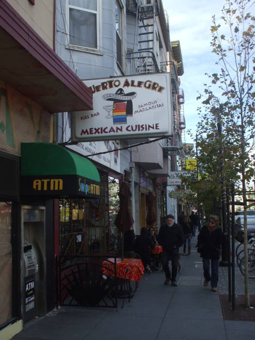
Muni buses 71, 71L, 7 and 6 run from Haight-Ashbury to Market Street. Turn south and walk a few blocks to get to the Mission District. There are many places there with good Mexican food.

Vintage streetcar in San Francisco.
San Francisco Muni ticket.

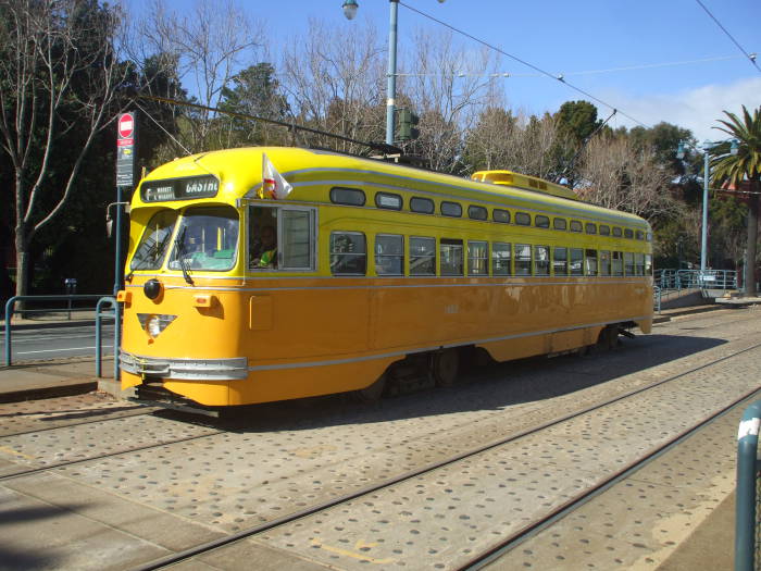
Muni, or, to be formal, the San Francisco Municipal Railway, operates vintage street cars on the F or Market and Wharves line. It runs along Market Street from 17th and Castro, passes the north end of the Mission, continues through downtown, and then turns and follows the Embaracero to the very touristy Fisherman's Wharf area.

Twenty-seven of the vintage streetcars date from 1946-1948 and served in the fleets of Philadelphia and Newark. This bright yellow one is an example of that group.

Another eleven were built in 1928 for Milan, Italy. Five were built for San Francisco in the years 1895-1924. Another ten are from various international cities: Blackpool, England; Hamburg, Germany; Osaka, Japan; Kobe and Hiroshima, Japan; Melbourne, Australia; Moscow, Russia; Porto, Portugal; and Brussels, Belgium.

San Francisco - Oakland Bay Bridge.

The Embarcadero is the waterfront facing east across the bay toward Oakland and Berkeley. It's also the name of major street running parallel to the waterfront, past the piers. The elevated Embarcadero Freeway was built through there in the 1960s, blocking off the view of the bay. But the freeway was condemned after the "World Series Earthquake" in 1989 and demolished soon afterward. It's now a nice area.

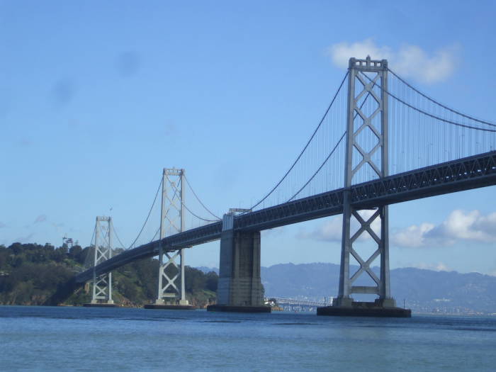
The San Francisco - Oakland Bay Bridge joins those two cities by way of Yerba Buena island. The total length is almost 4.5 miles, a little over 7 km, with nearly equal spans from San Francisco to the island and from the island to Oakland.

The western span, seen here, is a double-decked suspension bridge. The eastern span is a double-decked cantilever bridge and truss causeway. It was opened to traffic in November 1936, six months before the Golden Gate Bridge. The eastern span is currently being replaced.

The large cranes visible at the Port of Oakland inspired George Lucas' vision of the Imperial Walkers in The Empire Strikes Back. More recently, William Gibson's novels Virtual Light (1993), Idoru (1996), and All Tomorrow's Parties (1999) are set in the near future when the Bay Bridge has been converted to a complex home for many people.

Coit Tower on Telegraph Hill in San Francisco.

The Coit Tower is a decorative tower built on top of Telegraph Hill. The hill's name comes from the large semaphore or "maritime telegraph" built at its peak in 1849. The two-armed semaphore signaled the arrival and nature of the ships entering the Golden Gate. Merchants, wholesalers, and financial speculators used the signals in their businesses. The electrical telegraph system arrived in 1862 and the now obsolete semaphore was dismantled.

We're looking up at Coit Tower from the Embarcadero. The Filbert Steps are a steep staircase leading up from the east, taking the place of Filbert Street which continues west across the city from Telegraph Hill. The staircase runs through an area used as a rock quarry to gather ballast for ships tied up at the nearby piers. The Filbert Steps are straight ahead of us in this view.

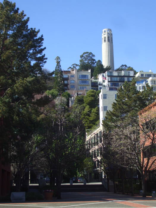
Coit Tower was built in 1933. It was a gift to the city from Lillie Hitchcock Coit, a socialite who loved to chase fires. She left one third of her estate to the city "to be expended in an appropriate manner for the purpose of adding to the beauty of the city which I have always loved." It's an Art Deco tower. Its base features murals painted under the Public Works of Art Project, a New Deal employment program during the Depression.

Looking from Telegraph Hill toward San Francisco - Oakland Bay Bridge.

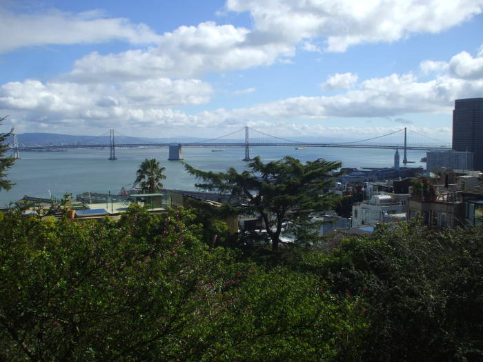
We're nearly at the top of Telegraph Hill, looking back down over the Embarcadero and across the bay. Oakland is beyond the left end of the bridge in this view. Further to the right we're looking all the way down San Francisco Bay to the San Jose area, about thirty miles away.

Alcatraz prison island in San Francisco Bay.

Alcatraz Island or "The Rock" is a mile and a half north of San Francisco's waterfront.

It was a military installation for many years. In 1861 it was used to house Confederate prisoners of war, beginning its use as a prison. It continued as a military prison after the Civil War. In 1933 is was deactivated as a military prison and transferred to the U.S. Bureau of Prisons. It was a federal penitentiary until 1963.

The theory that always that it was "escape proof" given the cold water and currents in the bay. Officially, there was never an escape. Now the annual Escape from Alcatraz Triathlon begins with a 2.4 km swim from Alcatraz Island to San Francisco, a 29 km bicycle ride, and a 12.8 km run. Recent years have seen 1700 or more participants. So much for the "escape proof" theory.

Looking from Telegraph Hill toward the Golden Gate Bridge and the Marin Headlands.

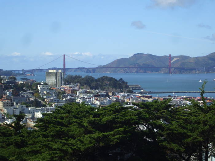
We're looking northwest from Telegraph Hill to the Golden Gate with its famous red-orange suspension bridge. The Marin Headlands are beyond the bridge.

Looking toward Russian Hill from Telegraph Hill in San Francisco.

Russian Hill, which we're viewing from Telegraph Hill, was named when Gold Rush era settlers discovered a small Russian cemetery at its top.

The bodies were never identified, but they were probably traders and sailors based at Fort Ross, an old Russian port on the Pacific a short distance north of San Francisco.

Fort Ross — Форт-Росс or originally Крепость Россь — was the hub of Russian America. It was established in 1808 and flourished until the 1830s. The Russian-American Company in Sitka sold it to John Sutter in 1841.

City Lights book store and the Transamerica Tower in San Francisco.

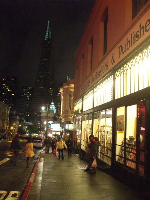
City Lights Bookstore was founded by Lawrence Ferlinghetti and Peter Marin. Ferlinghetti published Allen Ginsberg's book Howl and Other Poems in 1956, leading to his trial for obscenity. He still works in the store.

City Lights is sort of on the boundary between Chinatown and the North Beach area. We're looking down Columbus Avenue past the north end of Chinatown to the Transamerica Tower.

The associated publishing company has published many books by the Beat Generation and others.

SBC/ATT facility at #611 Folsom Street in San Francisco.

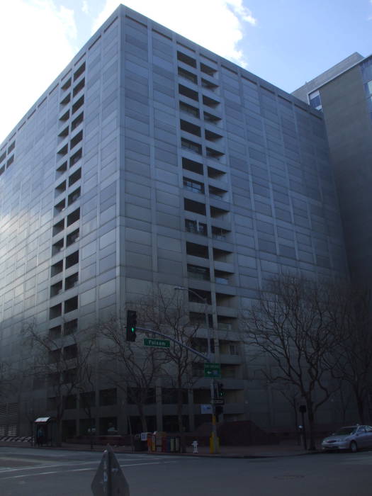
If hanging out in Haight-Ashbury and browsing at City Lights got you worked up for a protest, this is the AT&T/SBC facility at 611 Folsom Street, a regional switching center.

This is where the NSA's warrantless surveillance operation ran an intercept facility in room 641A. The room was described in AT&T internal documents as the "Study Group 3 Secure Room". Beam splitters were installed in the fiber optic trunks carrying Internet backbone traffic, and fiber optic lines ran to racks of equipment, including a Narus STA 6400, in room 641A. The Narus unit was designed to intercept, analyze and collect high-speed Internet traffic.

Pacific Tradewinds hostel in San Francisco.

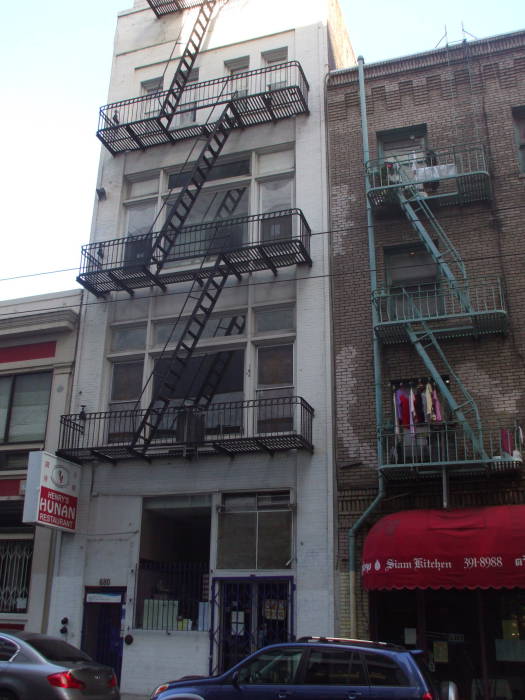
I've stayed a few times at the Pacific Tradewinds hostel, on the edge of Chinatown and easy walking distance to North Beach, the Embarcadero, and Market Street. It's upstairs in the white building seen here. They're at 680 Sacramento Street, +1-415-433-7970, sanfranciscohostel.org.

Another place I've stayed is the Green Tortoise.

A number of places rent bicycles, and it's easy to get to the Golden Gate Bridge.

View north along the Golden Gate Bridge from San Francisco toward the Marin Headlands.

Through the 1800s and into the early 1900s, San Francisco was the largest American city served primarily via ferries. But the experts mostly said that the two kilometer strait with its strong tides and currents, high winds, and 150 meter depth at its center could not be bridged.

The winning proposal was from Joseph Strauss, "an ambitious but dreamy engineer and poet" who had designed a 55 mile railroad bridge to cross the Bering Strait for his graduate thesis. Given everyone's lack of interest in building such a thing, driven by the complete lack of railroad lines within several hundreds of miles of either end, his practial accomplishments to date had been 400 drawbridges, mostly over inland rivers.

Strauss was made chief engineer for overall design and construction, but engineering and architectural design was left to others.

Charles Alton Ellis was the principal engineer. He was a Greek scholar and mathematician who had been a Univerisity of Illinois professor of engineering despite not having an engineering degree. Strauss fired him in 1931 and replaced him with one of his subordinates. Ellis was obsessed with the project and could find no other work during the Depression, so he continued working up to 70 hours per week without pay, and he eventually submitted ten volumes of hand calculations. He eventually completed a degree in civil engineering from the University of Illinois, and later worked for twelve years at a professor at Purdue University.

Strauss downplayed the work of others and managed to get most of the credit for the design and construction. The record was rectified in 2007, when the formal report on 70 years of stewardship and operation of the bridge gave Ellis credit for most of the bridge's design.

View southeast from the Marin Headlands over the Golden Gate Bridge to San Francisco.

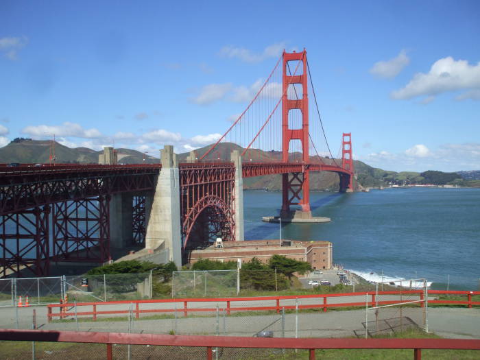
The U.S. Navy wanted it painted in black and yellow stripes for visibility to ships, but the International Orange sealant was kept as the final color.

There are pedestrian and bicycle walkways on either side of the six traffic lanes. Bicyclists can use it 24 hours, pedestrians during daylight hours only.

The Marin Headlands have great views down across the Golden Gate and to the city. The light at sunset is especially nice.

There are a number of large naval gun emplacements and bunkers built starting in the 1890s to prevent hostile ships from entering San Francisco Bay. This was the time of the Spanish-American War and the Russo-Japanese War (or Русско-Японская Война or Nichi-Ro Sensō) of 1894-1905. Further batteries were built into the initial years of World War II.

The area continued to host defensive facilities into the Cold War. SF-88 was a Nike Missile launch site from 1954 to 1974, intended for defense against Soviet bomber aircraft. The Nike-Hercules was a two-stage solid fuel surface to air missile carrying a W7 (2.5-28 kiloton) or W31 (2-20 kiloton) nuclear warhead, or a 770 kg high explosive warhead. It had a range of 90 miles and a flight ceiling of 150,000 feet.

Outside San Francisco

California redwood trees in Muir Woods.

Muir Woods National Monument is just twelve miles north of San Francisco. It protects one of the few stands of old growth Coast Redwoods in the San Francisco Bay area.

The area of Muir Woods is cool and moist all year. Rainfall is heavy in the winter. Summer moisture is provided by coastal fog drip. The result is lush growth that pictures just can't capture.

The mature redwoods here have average ages between 500 and 800 years, with the oldest at least 1,200 years old. The tallest tree in the Muir Woods is 258 feet tall, although redwoods can grow to nearly 380 feet. The distinctive fibrous bark can be up to 3 feet thick at the base of the tree.

Mossy growths in Muir Woods.

The ancestors of todays redwood and sequoia trees grew throughout North America 150 million years ago.

Today the various subspecies of Sequoia sempervirens are found only in a narrow belt paralleling the coast from Monterey Bay to today's Oregon.

Around 1800 AD, there were an estimated 8,000 square kilometers of old-growth forest containing redwoods in a narrow strip along the Pacific coast from Monterey Bay to today's Oregon.

By the early 1900s, most of those forests had been cut down. A U.S. Congressman purchased a 611-acre tract of land in southwestern Marin County and donated it to the Federal Government.

Theodore Roosevelt declared the land a National Monument in January, 1908.

Redwood Creek, which flows through Muir Woods, is a crucial spawning habitat for three endangered species: Oncorhynchus kisutch, the coho or silver salmon; Oncorhynchus clarki clarki, the coastal cutthroat trout; and Oncorhynchus mykiss, the steelhead trout. The salmon migrate down river and out to sea, returning typically after two years to spawn. The coho salmon population in California down to just 1% of the levels seen in the 1940s, and they have disappeared from 90% of the streams where they used to be found.

The United Nations Charter was drafted and signed in San Francisco in the spring of 1945. President Franklin Delano Roosevelt had died on April 12th, shortly before he was to have formalled opened the United Nations Conference.

The United Nations delegates held a commmemorative ceremony in what is today called Cathedral Grove within Muir Woods. Harold Ickes, the U.S. Secretary of the Interior, said:

...here in such a "temple of peace" the delegates would gain a perspective and sense of time that could be obtained nowhere in America better than in such a forest. Muir Woods is a cathedral, the pillars of which have stood through much of recorded human history..."

You could continue further north to Sonoma County. It was originally settled by the Pomo, Coast Miwok, and Wappo people around 8000-5000 BC. The Russians and their Fort Ross or Крепость Россь settled along the coast 1812-1841 AD. Meanwhile the Spanish established some missions inland, starting in 1823.

Jack London, who was a real piece of work, owned a ranch here in the early 1900s. London's mother was Flora Wellman, a spritualist who claimed to channel the spirit of an Indian chief. His father seems to have been the astrologer William Chaney.

Flora became pregnant, Chaney demanded that she have an abortion, Flora refused, Chaney denied all responsibility, and Flora shot herself. She was not seriously injured, but she was "temporarily deranged." She had the baby, Jack, on January 12, 1876, and turned him over to an ex-slave who remained a major maternal figure to Jack. This seems to have been one of the most sane decisions he ever made.

Jack was, in quick succession, a cannery worker, an oyster pirate, a jute miller, and a tramp. Only then did he attend high school, followed by a year at the University of California, Berkeley. While at Berkeley, Jack wrote to Chaney in Chicago. Chaney relied upon the defense of impotence and casually asserted that Flora had had sexual relations with other (non-impotent) men. Jack left immediately for the Klondike Gold Rush.

California vineyards in Sonoma Valley.

London returned, married, divorced, was a member of the Bohemian Grove, then married again in 1905 to Charmian Kittredge, a woman to whose uninhibited sexuality every biographer seems to have alluded. Later that same year Jack and Charmian London purchased a 1000 acre ranch in Glen Ellen, Sonoma County.

Amongst all the uninhibited sex, strident socialism, and terrified racism, Jack London wrote or at least plagiarized a large number of books and stories about socialism, dogs, the Yukon, communism, wolves, and sailing, rendering him almost as amusing a target of parody as Ernest Hemingway.

Today, Sonoma is a center of the California wine industry, producing significantly more than its competitor, Napa Valley, one mountain ridge and valley to the east. The description that I got was that Napa is all about the image and the weekend getaways, while Sonoma produces the grapes and the wine. Sonoma County produces over 150,000 tons of grapes worth over $310 million.

Here is a view of Benziger Winery, which uses a strict "biodynamic" regimen. This goes beyond being simply sustainable or organic, as it uses a closed nutrient cycle within their facility. A tour of a winery like this is very interesting, even if you aren't a brewing nerd. Not only is some of their wine based entirely upon grapes grown locally in their self-contained biodynamic system, but even the yeast is an endemic local strain.

Big Sur highway along the Pacific Ocean.

You can drive the opposite direction from San Francisco, south along Highway 1 through Monterey and into Big Sur.

The stretch of coast between Carmel and San Simeon is still sparsely populated. In the 1920s, only two homes in the region had electricity, and that was locally generated by windmills and water wheels. Most of the small population had no electrical power until connections were made to the California grid in the 1950s.

The two-lane Highway 1 was finished in 1937. There are still no towns along that stretch of coastal road, although road maps tend to mark three small clusters of gas stations, restaurants, and motels as though they were. There are less than 300 hotel rooms along the 90 miles, none of them in chain hotels, only three gas stations, and no fast-food outlets or supermarkets. Most of the lodging and restaurants are clustered within a stretch of a few miles where the highway leaves the coast and winds through a redwood forest while crossing the Big Sur River valley.

The coastline is rugged, as the Santa Lucia Mountains rise out of the sea, forcing the road to follow a narrow ledge. The mountain range inland is one of the largest roadless regions near a coastline in the continental U.S. The varied topography creates many closely space microclimates, producing a few very unusual places where redwoods and cacti grow within sight of each other.

The drive along Highway 1 is probably the most scenic scenic driving route in the United States and it is one of the top drives in the world. Above is a picture of the Bixby Creek Bridge, just 13 miles south of Carmel. This stretch of Highway 1 has been the setting of many automobile commercials. The bridge, finished in 1932, is 714 feet long and over 280 feet high. Until it opened, the 30 mile trip from Monterey to the Big Sur River valley took a day and a half in each direction.

Other Travel Destinations

United States

International Travel

Click here to inquire about advertising on this or any page on this site.
Home Unix/Linux Networking Cybersecurity Travel Technical Radio Site Map Contact


Use /bin/vi! Manipulate images with ImageMagick! Hosted on OpenBSD
Hosted on Apache This site is viewable with any browser Valid XHTML 1.0! Valid CSS!
© Bob Cromwell May 2012. Created with /bin/vi and ImageMagick, hosted on OpenBSD with Apache.    Root password available here, privacy policy here.