The Battle of the Bulge
Bastogne and the Ardennes Forest
Preparation
A friend of mine organized a World War II history trip. Three of us ended up going. We started by flying to Brussels and renting a car. We first drove to Normandy and the D-Day beaches, staying in Sainte-Mère-Église and touring most everything from batteries inland from Utah Beach in the west to Pegasus Bridge in the east. Then we drove to southern Belgium and stayed in Bastogne for a few days seeing the area where the Battle of the Bulge was fought. Click here to see the D-Day section first.
There are some good books on the history. Steven Ambrose's Citizen Soldiers is outstanding. It starts where his D-Day leaves off and continues through the end of the war.
The battle itself was a major German offensive and Allied counter-offensive lasting from 16 December 1944 through 25 January 1945.
I had a preconception of the Ardennes area of southern Belgium as being largely rural, forested and hilly. Then I would think about what little I knew of Belgium, which was the flat, wide open and heavily settled northern part. I would assume that my assumptions were wrong.
But the Ardennes area is rural, forested and hilly! Julius Caesar described it as "a place full of horrors", dark forests with muddy paths and perpetual fog rising from the peat bogs. His army took 10 days to march across it.
Logistics
We had a rented car, which is vital for seeing much in the area without spending many extra days waiting on bus transport.
We rented a car from Europcar, they are a major car rental company with locations throughout Europe and what seem like relatively good prices.
We picked up our Europcar at Brussels Midi Station where the Thalys and Eurostar international trains from France and the UK call. Brussels is very well connected by rail to the rest of Europe, and there are direct flights from North America. A train runs from the airport to the Midi Station every 30 minutes or so.
You will need to be able to use a manual transmission when you rent a car outside the U.S. Most drivers world-wide know how, and they will just assume you also do. If you don't know how, check carefully when reserving your car. They may have a few cars with automatic transmissions, but at reduced selection and therefore increased price.
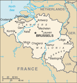
US Government map of Belgium.
| Oddball: | This engine's been modified by our mechanical genius here, Moriarty. Right? |
| Moriarty: | Whatever you say, babe. [giggles] |
| Oddball: | These engines are the fastest in any tanks in the European Theater of Operations, forwards or backwards. You see, man, we like to feel we can get out of trouble quicker than we got into it. |
| Kelly: | [looking skeptical] Got any other secret weapons? |
| Oddball: | Well, yeah, man, you see, like, all the tanks we come up against are bigger and better than ours, so all we can hope to do is, like, scare 'em away, y'know. This gun is an ordinary 76mm but we add this piece of pipe onto it, and the Krauts think, like, maybe it's a 90mm. We got our own ammunition, it's filled with paint. When we fire it, it makes... pretty pictures. Scares the hell outta people! We have a loudspeaker here, and when we go into battle we play music, very loud. It kind of... calms us down. |
You will also need to use the Metric system when you are outside the U.S. Kilometers, meters, litres, and so on. Well, unless you visit either Liberia or Myanmar (ex-Burma). The only countries in the world still using the Imperial system of measurement are Liberia, Myanmar, and the U.S. Really. And Metric is way easier:
- 1 cm on a 1:100,000 map = 1000 m or 1 km in the world.
-
1 inch on a 1:100,000 map corresponds to
100,000 inches,
so divide by 12 to get 8333.333333 feet,
and then divide that by 5,280 to get
1.5782828 miles.
1 inch on the map = 1.5782828 miles in the world.
And if you're using the UTM grid on your GPS, you can read it directly in meters or kilometers.

Lord Vader says: "I find your lack of understanding of the Metric system disturbing."
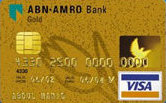
A modern credit card with an embedded smart chip and ISO standard electrical contact pad.
There's one more possible inconvenience caused by the U.S. being a little behind the rest of the world in some ways: Almost all countries' banks now issue credit cards that are smart cards, with electrical contacts and an embedded chip. It's a very nice security feature, you must use a PIN to use the card and so a stolen card simply cannot be used. All Australian credit cards have been smart cards since 1985. The problem is that old-fashioned American credit cards don't work in a lot of the automated kiosks, for example, the handy system that sells tickets in French train stations. We have to go stand in line with all the other Americans at the staffed ticket window where we can still use our quaint no-security cards.
Update — In mid-2014 the U.S. announced that in a few years they would transition to the smart card technology that has been used in France since 1992 and in Australia since the mid 1980s.
Further update — In mid-2018 many U.S. cards had chips.
