
Puerto Williams
Southernmost Town in the World
Puerto Williams is the only town on
Isla Navarino,
making it the southernmost town in the world.
It's at 54° 56' S,
while the southern tip of New Zealand's South Island
is at 46° 41'S,
and the southern tip of Tasmania is at 43° 39'S.
Entire continents stop even further to the north,
with the southern tip of Australia at 39° 8'S,
and the southern tip of Africa at 34° 50'S.
Puerto Williams with almost 2,900 residents is clearly
a town while nearby Ushuaia, Argentina,
a little to the north with almost 83,000 residents,
is clearly a city.
Puerto Williams was established as a naval base in 1953.
When the below chart was compiled in 1965,
the town itself didn't merit inclusion.
But the airstrip used by the Chilean Navy and Coast Guard
was included.
See the blue circle labeled GUARDIAMARINA ZAÑARTU,
on a peninsula northwest of the town.
That's now the civil airport,
with a single 1,440-meter runway.

Isla Navarino and nearby islands on 1:1,000,000 aeronautical chart ONC T-18, from the Perry-Castañeda Library Map Collection at the University of Texas at Austin. The chart was compiled in 1965, with aeronautical information updated in 1985.
Here's a Wikipedia map of Chile's Magallanes y la Antártica Chilena Region, in light yellow and red. It is the part of Chile that you can't drive to from the rest of Chile without a long detour through Argentina. The white box in the north is an area of disputed border between Chile and Argentina.
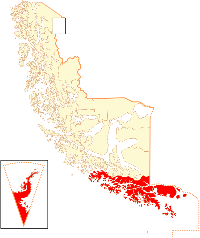
Highlighted in red is Antártica Chilena Province. It is divided into two communes — Antártica Commune, Chile's wedge-shaped claim of the continent of Antarctica in the much smaller scale inset, and Cabo de Hornos Commune. Puerto Williams is the administrative center of the Province and both Communes.
Finally, here's a map of Puerto Williams and surroundings from OpenStreetMap.org.

To My Lodging
Ferry trip to Puerto WilliamsHere's the last picture from my page showing the wonderful 30-hour ferry trip from Punta Arenas to Puerto Williams. We were landing just a few minutes before midnight, exactly as planned. The ferry landing is straight ahead of the ferry's green ramp. My destination is a short distance off to the left of what's visible here.
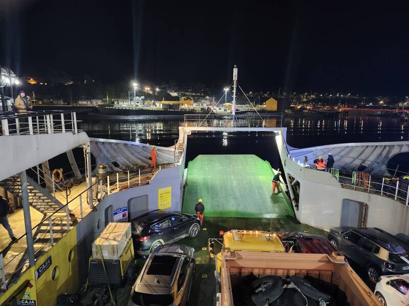
Note that Google Maps shows the ferry from Punta Arenas using a joint Coast Guard / Navy dock about 700 meters to the west, well off to the right of this view. I think that no one living in Puerto Williams bothers with trying to straighten out Google Maps, because the residents certainly know where things are. As for visitors, it's a small place and easy to figure out.
I had a reservation at Refugio Jemmy Button, which was a short walk from the ferry terminal. Exit to the waterfront road and turn left, and it's just 150 meters away.
Guesthouses at Booking.comThe next day, when it was light, here's what Refugio Jemmy Button looks like. I had reserved my room via Booking.com, but they take a large commission. Why not set up your reservation directly, via email to refugiojemmybutton@gmail.com or via WhatsApp at +56-9-8185-3129.

Arturo, my innkeeper, was waiting for me. He has four guest rooms, behind the large windows seen above, with a large shared living room and kitchen and then his quarters to the left.
In Chile, a hostal is a lower-priced hotel, where some or all rooms have shared baths. But the rooms are all private, it's definitely not a hostel where you sleep in a shared room.
A refugio, literally "refuge" in English, is a simple guesthouse or a hut along a trekking path, as in Torres del Paine National Park. Refugio Jemmy Button may have been rougher when it first opened, but I would describe what you see here as a hostal. However, what do I know.
We had some wine and talked for a while, but the ferry had arrived at midnight and eventually it was time for bed. Here's my room:

The door seen above led to my bathroom. My own full private bath, definitely a hostal or higher grade.


My large window is behind the brown curtains, next to the door out onto the porch. Left of the door is a gas heater for my room. Arturo hadn't given me a key, I asked about a key for the door. Oh, there aren't locks. There are hasps so you could padlock your room when you were away, if you had a padlock and wanted to use it. However, Isla Navarino isn't a door-locking type of place.

I made certain that I knew how to light and turn off the heater without blowing myself up or asphyxiating myself.

In the morning I saw that I had a beautiful view out across the Beagle Channel.

The M/V Kawéskar remained at Puerto Williams until 1600 the following day. You can see how short the walk was from the ferry ramp to my room.

The veranda was a new addition, still under construction during my stay.

The road continues to the right, to the east, although the pavement ends after about a hundred meters.

I went into the common area where we had sat the night before, and talked more with Arturo. If the refugio fills up, there's one last bed in the shared area.
A couple that had been staying there would leave on that afternoon's ferry back to Punta Arenas, and then it would be just me. Arturo asked me if I hadn't noticed another foreign visitor on the ferry. No... Someone from Germany was supposed to have arrive the previous night.

Breakfast was avocado and grilled chicken on toasted bread, along with instant coffee.

After breakfast, Arturo asked me if I was ready to go. Huh? Go where?
To the supermarket, of course. Everyone buys groceries on Saturday morning, because the ferry brings supplies on Friday night.
Simon & Simon is the largest supermercado in town. It's on Calle Piloto Pardo, directly across from Supermercado Temuco, a smaller competitor. Many items are available only at one or the other.
We hopped in his car and went to Simon & Simon, and then he gave me a quick tour through town.
After returning and putting the groceries away, he said that there was something outside of town to the east that he wanted to check on, and maybe I wanted to ride along. Sure! All that's on a later page.
Through Town
Later that first day and on following days I walked through town. That started by going back past the ferry ramp.

A mix of homes and refugios plus a coffee shop are along the waterfront road. A street branches off to climb the hill to the center of town.

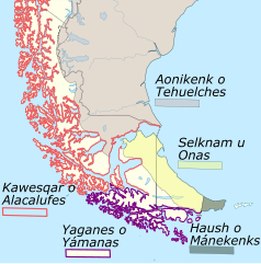
I noticed signs from local groups opposing commercial salmon farming in the Beagle Channel. Salmon farms have caused ecological problems along Chile's southern Pacific coast. Yagan, also spelled Yahgan and Yaghan, refers to the remaining indigenous people.

A Yahgan community is along the coast road on the east side of Puerto Williams. The last full-blooded native speaker of their language died there in 2022, from complications of COVID-19. There's more about the Yahgan in a later page.
I turned at the top of the hill and looked down over the port. Left of center are two piers used by commercial fishermen. Fishing is a big part of the local economy, in addition to the naval base, tourism, and support operations for scientific research from here to the South Pole.
The waterfront road curves around to the right and out of sight. The last orange building visible is the administration building for the ferry port.

Walking a short distance east and then turning to look back, I saw the partially snow-covered mountains across the Beagle Channel in Argentine Tierra del Fuego.
Closer were homes, a large fuel tank, and above the tank, the control tower for the airport with the runway partially visible. Aerovías DAP operates flights from Punta Arenas and back, one every day except Sunday.

Continuing to the center of town, where the streets named for national heroes Arturo Prat and Bernardo O'Higgins cross, at left is Correos de Chile, the post office. At right are flags in front of a government building — Cabo de Hornos Commune, Chile, and Magallanes y la Antártica Chilena Region, from left to right.

Small businesses like this small supermercado line the streets. At far right, Cosa de Hombres, "A Man's Thing", hardware and appliances.

Plaza Bernardo O'Higgins is a triangular park.


The plaza has an over-dressed representation of a Yahgan man prepared for an initiation ceremony.
The Yahgan people, along with the Selk'nam and the Haush (or Manek'enk) peoples who lived across the Beagle Channel on Tierra del Fuego, all spoke different languages but had similar initiation ceremonies.
Their initiation ceremonies for young men featured dramatic re-enactments of mythic events accompanied by tests for courage and resourcefulness. The adult men in the ceremony would paint their entire body in dark red, with white or black stripes. They played the role of sinister supernatural spirits.
All of the indigenous people in this area were extremely tough, and wore very little clothing even during winter. The Yahgan, the southernmost group, mostly went completely naked year-round. For the ceremonies, the adult men of all the groups wore nothing but paint and conical headdresses.
This of course did not go over well with the European missionaries, who immediately set about trying to get the locals to wear clothing. To this day, the Chilean government insists that public depictions be somewhat vague or show them in kilt-like garb that some of the groups wore on occasion.

What Arturo described as "the big square downtown" is north of the plaza at the west end of town, across from the high school and next to the naval base. That makes it sound like it's far away, but it's only two blocks from the top of the road sloping up from the ferry terminal. Puerto Williams is small, about 1,200 meters end to end including the naval base.
The square is lined with shops and restaurants, but be aware that many are open for only very limited hours and days.


Bistró del Sur is a good place to get dinner, and it's open every day except Sunday.

The local branch of Banco de Chile is just north of that square, on the edge of the naval base. It has a cash machine in its lobby, accessible at all times. Further inside is a teller window which is staffed from time to time.
It's next to a replica of the bow of the M/V Yelcho, a steam tug that rescued the stranded men of Shackleton's Antarctic expedition in 1916. There's also a Yelcho bow on the waterfront in Punta Arenas, beside a statue of its heroic captain Luis Alberto Pardo Villalón.

As best as I understand it, the Yelcho bow in Punta Arenas is the real one and this is a replica. Or possibly it's the other way around.
I've seen both, so I have seen the real one. I'm just not 100% certain which one it was.
The crux of the story is the Yelcho's heroic captain. See my page about Punta Arenas for the catastrophe of Shackleton's failed expedition and how Luis Pardo came to their rescue.
Heading east, I passed the hilltop campus of the local college, a branch of the University of Magallanes or UMAG in Punta Arenas. It incorporates the Cape Horn Center, a consortium of UMAG, the University of Chile, Pontifical Catholic University, Central University, University of Talca, Catholic University of Temuco, University of Los Lagos and the Center for Research in Patagonian Ecosystems in Aysén. along with an international network including the University of North Texas.

The university has programs in engineering, medicine, education, various branches of science, economics, and law.

I continued on toward the east end of town.

I saw the local
Iglesia Metodista Pentecostal de Chile.
Pentecostal Methodist?
I have no idea, to me that sounds like a contradiction...

The local Carabinero post has HF antennas, dipoles and folded dipoles. Microwave point-to-point links won't come close to reaching the rest of Chile.

I returned to where I was staying, passing other refugios, homes, and a two-story home with a coffeeshop on the lower level.


One afternoon I looked out the window and saw that the wild horses had come into town.


I walked up to Bistró del Sur that evening to get dinner, and saw wild horses grazing around the plaza.


Small ferries connecting across the Beagle Channel pulled in from time to time. They're traveling between Puerto Williams and Argentina, so there has to be a customs and immigration presence here.

The missing German guy arrived on my first full day there. Being German, of course he had traveled all over Europe. This was his first overseas flight. Starting from Frankfurt, he flew first to Buenos Aires, then to Santiago, and then to Punta Arenas. Then he had to stay overnight, and he had simply slept on the seats in the airport as several people do while waiting for the next day's flight to Puerto Williams. Like me, he had been uncertain of exactly when he would arrive in Puerto Williams.

Technical Matters — Internet Connectivity
I don't care, jump ahead to the next travel pictures!
A solid WiFi connection at Refugio Jemmy Button
gets you on the Internet.
How does this work?
Let's see what traceroute shows us
for a trace from Puerto Williams to where I live
close to the Purdue University campus.
Hop #1 is Arturo's wireless router, of course.
Hops #2–3
add significant latency, with significant variation.
Then hop #6 adds a little more latency while popping out
of reserved and special-use IP address space
at the Hurricane Electric backbone provider in Santiago.
Note that major providers tend to use airport codes
for DNS names of routers, and not all routers respond
reliably (hops 7, 8, 11)
or at all (4, 9, 15-17)
when the traceroute packets reach their
maximum hop count.
Hops 7–11 are on Hurricane Electric through Buenos Aires, Sao Paolo, a mystery hop, then Columbus, Ohio, and Indianapolis, Indiana, with latency increasing as it goes. Then hops 12–18 traverse a high-speed multi-university network, ending up at Purdue's engineering school's web server.
traceroute-puerto-williams-engr.purdue.edu
$ traceroute www.engr.purdue.edu
Selected device wlo1, address 192.168.1.20, port 38923 for outgoing packets
Tracing the path to www.engr.purdue.edu (128.46.104.20) on TCP port 443 (https), 30 hops max
 1  192.168.1.1  2.193 ms  1.014 ms  1.055 ms
 2  100.64.0.1  81.024 ms  101.361 ms  94.025 ms
 3  172.16.251.14  200.385 ms  94.893 ms  99.530 ms
 4  * * *
 5  undefined.hostname.localhost (206.224.69.198)  89.337 ms  101.139 ms  92.998 ms
 6  HurricaneElectric-6939.SCL.PITChile.cl (45.68.16.244) 164.657 ms  101.261 ms  101.076 ms
 7  * 100ge0-35.core1.bue1.he.net (184.104.188.168) 170.193 ms  203.233 ms
 8  * 100ge0-27.core3.sao1.he.net (184.104.188.73) 165.824 ms *
 9  * * *
10  100ge0-75.core1.cmh1.he.net (184.104.193.93)  273.753 ms  308.128 ms  303.344 ms
11  100ge0-76.core2.ind1.he.net (184.104.192.150)  301.725 ms * *
12  indiana-university-co-indiana-gigapop.e0-49.switch2.ind1.he.net (184.105.35.194)  341.117 ms  306.888 ms  301.227 ms
13  38.101.160.251  297.961 ms  306.209 ms  297.948 ms
14  192.5.40.2  297.735 ms  305.680 ms  298.508 ms
15  * * *
16  * * *
17  * * *
18  web-01-02-ha.ecn.purdue.edu (128.46.104.20) [open]  297.406 ms  304.911 ms  302.063 ms
So, what's going on with the first five hops,
almost identical to what I saw earlier on this trip at
Cerro Castillo
in Patagonia,
and on
Rapa Nui?
The whois command could explain this for
the IP address of hop #5,
or you can ask
whatismyipaddress.com —
it's Starlink.
206.224.69.198 was router #5's address on its
Puerto-Williams-facing side,
while 98.97.129.10 is its public Internet side,
where the route finally comes out of all the Starlink
network address translation
and non-IP shenanigans.

I would not personally choose to further enrich the ketamine-addled eugenicist Elon Musk, but in parts of Chile it's the only available choice so far.
Also, a study in July, 2025, showed that if Starlink use exceeds about 2.6 households per square kilometer, it doesn't meet the 100/20 Mbps minimum service level to qualify as broadband service.
Technical Matters — Smart Phone Photos
I don't care, jump ahead to the next travel pictures!Arturo asked me for help with his phone. I work with computers, so I must understand smart phones, right? OK, I'll try...
Banco de Chile had been telling him for some time that he needed to update to the latest version of their smart phone app. However, it wouldn't install on his phone. The bank, with just a minor presence in Puerto Williams, had dismissed his problem by saying that he probably should buy a new phone.
Well, let's have a look. Try to do the update while I watch.
It would not start the update because there wasn't enough free storage space on the phone. And there wasn't enough space because the phone still held every picture he had taken with it.
Sure, you've used all the space. Transfer the pictures to your computer and that should fix it.
Oh, there is the real problem. He has copied some to his computer before, but he can't look at them there.
What? Let's try that, transfer just a few and let me watch what happens.
Up pops an error window saying that the picture,
in a file named something like
IMG_20241010-163428.heic,
was of an unsupported type.
However, if you simply buy a Microsoft Photo application
for about US$ 300,
that would solve the problem.
Yikes, that's expensive nonsense!
High Efficiency Image File Format or HEIF is a container format for storing individual digital images, image sequences, video files, and other multimedia data. HEIC is an image and video encoding format and image codec used with HEIF. The resulting file is a little smaller than JPEG of the equivalent quality.
HEIF and HEIC were defined in 2015. By 2017, Apple released iOS 11 using HEIC. Android 10 in 2019 began to support it. However, Arturo's Windows laptop and desktop did not.
Handling other people's precious data makes me worry, so just as I would with any consulting client, I looked for someone to whom to narrate what I was doing. Not because they necessarily know anything at all about what's happening, but because I know that describing what you're doing forces you to think carefully about what you're doing. By then Michel, the missing German, had arrived. He's a carpenter, and so he's interested in hands-on things. OK, gather around if you want, this is fixable.
First, let me make sure that my Linux laptop interfaces with Arturo's Android phone. I want to do this work from the command line, so I'll make sure I have everything installed and then terminate the graphical auto-mounting component.
$ sudo apt install mtp-tools android-file-transfer
[... I already had that installed for my phone, of course ...]
$ pkill gvfs
$ mkdir /tmp/phone
$ aft-mtp-mount /tmp/phone/
$ df -hT /tmp/phone/
Filesystem     Type                Size  Used Avail Use% Mounted on
aft-mtp-mount  fuse.aft-mtp-mount   61G   59G  2.5G  96% /tmp/phone0
[... Yes, his phone is pretty full ...]
$ ls /tmp/phone/Internal\ storage/DCIM/Camera/
[... THOUSANDS of *.heic filenames appear! How many? ...]
$ ls /tmp/phone/Internal\ storage/DCIM/Camera/ | wc -l
3867
So, my plan is:
- Copy (and not move!) all the HEIC image files to a working area on my laptop.
- Insert an empty USB storage stick.
-
Type a Bash shell loop that goes through
the HEIC files, using the
ImageMagick
convertcommand to convert it to JPEG with the same quality, storing the result in a similarly named*.jpgon the USB stick. - Verify that the USB stick now contains as many JPEG files as Arturo's phone contains HEIC files.
- Hand the USB stick to Arturo and have him move, or copy, all the JPEG files onto his computer. Then verify that they look good. Then, when he's certain that the result is good, he can delete all of the pictures off of his phone.
$ mkdir ~/arturo
$ cd ~/arturo
$ cp -v /tmp/phone/Internal\ storage/DCIM/Camera/* .
[... Copying verbosely because it will take a while, and it's
     good to have feedback that something is happening. ...]
Now I inserted the USB stick, and:
$ for f in *
> do
>   convert $f /media/cromwell/usbstick/$( echo $f | sed 's/heic/jpg/' )
> done
$ ls -1 | wc -l
3867
$ ls -1 /media/cromwell/usbstick/ | wc -l
3867
The counts of old *.heic files and new
*.jpg files matched,
so I unplugged the USB stick and handed it to Arturo.
"OK, move all the files on here to your computer
and make sure that they look good."
Michel was puzzled and asked when I would start the long job of right-clicking and converting 3,867 image files. "Oh, I already did that, see that 4-line loop?"
Arturo was delighted.
I helped him adjust his phone settings so that pictures were stored as JPEG. Depending on your phone OS, "Most portable" may be a choice. For mine, you have to know that HEIC is also unsupported by Windows, without an enormous charge for an added application. Or, by adding ImageMagick, which also runs on Windows.

Centolla and Other Seafood
Fishing has been second only to the naval base for the economy of Isla Navarino. In particular, what is locally known as centolla.
Centolla, or the southern king crab or Chilean king crab, is known to science as Lithodes santolla. It lives on the seabed in the cold water around the southern tip of South America, at depths down to 700 meters. Its carapace or main body can grow to 20 centimeters across.
It's a lucrative fishing opportunity. Centolla fishing, along with speculation of gold deposits on the Picton, Lennox, and Nueva islands just east of Isla Navarino and generally accepted as Chilean territory, led the ruling Argentine junta in 1978 to bring the country to the verge of war against the similarly junta-ruled Chile. Argentina came within hours of launching an invasion in late December 1978. Pope John Paul II announced that he was sending a special envoy to sort out the dispute. The Papal mediation continued through 1984, and it wasn't until the 1990s that Chile and Argentina resolved most of their disputes.
Centolla fishing was one of the main reasons for the 1953 establishment of the Chilean Navy base on Isla Navarino. Both the Navy and the Coast Guard patrol the nearby waters, monitoring Argentinian fishing boats to ensure they don't cross into Chilean waters.
Much of the centolla is immediately shipped to Asia, but Arturo knows a guy. One day he made pasta with a creamy sauce and centolla.

I had ceviche with tuna and salmon one evening at Bistró del Sur.

Another time at Bistró del Sur I had large ravioli stuffed with centolla.


My last evening in town, I had centolla baked in creamy cheese sauce at the Worus brew pub and restaurant.

Chilean Navy Base
The joint Chilean Navy and Coast Guard base is the reason for Puerto Williams' existence.

The base is at the west end of town. The airport is on a peninsula extending into the Beagle Channel, it also was created for the Navy.

Between the base and the airport is the yacht harbor. Sailors doing an around-the-world cruise stop here. It's centered on the Micalvi, a grounded German cargo ship. It was declared a regional naval museum in 1976 but has become a members-only bar for the yachting community.

Up the hill on the base itself, the base church with its light green roof is the main landmark of Puerto Williams. It has a steep roof because of the deep snowfall this far south.
In front is an LVTP 5 amphibious vehicle, for landings from a naval transport ship and then all-terrain, all-weather operation.

The Navy base isn't very exciting — administrative buildings, a gymnasium, housing, and a small hospital that used to be the only hospital in the region. Now there's a small civilian hospital at the center of town.
Two Coast Guard patrol boat and a Navy patrol boat when I took the below picture. The primary mission is routine patrols to make sure that Argentinian fishing boats stay within Argentinian waters.
Note that Google Maps shows the ferry from Punta Arenas using this joint Coast Guard / Navy dock.

English and Spanish scientists have slightly different ways of spelling the groups' names, and they're different approximations to how they named themselves in their now extinct languages. Or, for the Haush, what seems to have been a derogatory name used by the Yahgan.