
The Fortress
Taormina's Arab-Norman Fortress
The Greek colonists who relocated to today's Taormina
from the nearby port of Naxos
built a literal acropolis,
a defensive citadel on a high point.
There would have been improvements by
the Romans who took control in 21 BCE,
and then the Byzantines who controlled Taormina from the
mid to late 4th century until the mid 10th century.
An Arab army of the Fatimid Caliphate beseiged the city
for thirty weeks, capturing it in 962.
They carried out a major redesign and reconstruction
of the mountaintop fortress.
When the Norman count Roger I of Sicily captured the town
in 1078, he made few modifications to the fortress.
By 1134, a monastery had moved in to the fortress.
Around 1640, a chapel and hermitage were built on a
lower outcropping.
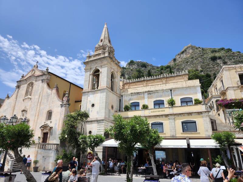
Both the chapel and hermitage are clearly visible
from Piazze IX Aprile in the center of Taormina.
The white cross above the chapel is visible just to the
right of the church tower in this picture,
and the fortress is on the higher peak to the right.
Planning the Walk
The way up is very obvious, but Google Maps manages to make it confusing by also showing the express highway running through a tunnel beneath the mountain unless you're in "satellite mode".
- Go to Porto Messina, the old city gate at the northeast end of Corso Umberto, the main street running through the old town.
- Walk uphill to the intersection with the road running along the uphill side of the town.
- Turn left, and walk about 200–250 meters, watching for a staircase leading up to your right.
This map shows the route from where the stairs begin.
I didn't count, but the Blue Guide says that it's 738 steps to climb up to the fortress. Per Google Maps, the steps start up from the road at 228 meters elevation. The chapel is at 350 meters. The highest point on the fortress is at 400 meters, so you face an elevation gain of 172 meters going up the steps. Take water. There's no shame in sitting down to rest while enjoying the view.

When I reached the highest point on the fortress, the GPS receiver on my phone claimed that I was at 444.4 meters, about 44 meters above the actual elevation. GPS is quite good for horizontal position, latitude and longitude, but it's much less accurate for elevation.
GPS accuracy is subject to errors from various sources, up to approximately:
- ±5 meters from ionospheric signal dispersion, slight delays of the 1575.42 and 1227.60 MHz signals, plus
- ±0.5 meter from tropospheric (weather) signal dispersion, plus
- ±2.5 meters from ephemeris errors, deviations of satellites from their expected paths, plus
- ±2 meters from satellite clock errors, plus
- ±4 meters from receiver clock errors, plus
- ±1 meter from multipath signal errors
That combines into an error of up to 15 meters in horizontal position. Because elevation measurement can only use satellites above the receiver position, the vertical error is two to three times larger, or 30–45 meters. Further issues including local deviation from the reference geoid add to that error. GPS location accuracy is a bottomless rabbit hole of detail.
"But, but... cruise missiles can fly into specific windows!", you object. Cruise missiles use GPS to get to the general vicinity. But they also carry a radar altimeter to accurately measure elevation above the terrain. They can also turn on a camera or possibly millimeter-wave radar and look for the target. In the 1990s they used DSMAC, Digitized Scene-Mapping Area Correlator, but I don't know what newer systems might use.

Preparing
My LodgingI was starting from where I was staying, in an apartment down the northeast access road toward the bus station. The fortress was in view most of the way up the road to where I got a late breakfast.

My usual breakfast — multi-grain cornetto and doppio caffè. Over breakfast I was making plans for my next stop, Siracusa and, a short distance south of town, the site of a British glider assault on an important bridge, part of the overall Operation Husky, the Allied invasion of Sicily in 1943.

in Taormina
Fortified and caffeinated, I visited some of the ruins from the colonial Greek era off Taormina. Then I was ready to continue up the hill to the right of the ancient city wall gate.


Preparing
Overnight onMount Sinai
Above is the view up the bottom end of the staircase. Go on, you can do it. It's not like you're climbing the Stairs of Repentance. Well, unless you want to be one of those grim and humorless Stoics who delight in taking the delight out of everything.
Take breaks, enjoy the view, and pick out landmarks. Near the horizon toward the left here is the heavily reconstructed ancient Greek theatre. Immediately in front of it are some high-end hotels where Martin Scorcese and pals probably stay during Taormina's annual film festival. Rising above the waterline beside the tall dark cypress toward the lower right, that's Chiesa di San Giuseppe on Piazza IX Aprile.

A little higher, and the view shifts.

And shifts again.

The chapel is largely hidden from view as you ascend, but the fortress is unmissable.

The chapel becomes obvious in the final stretch. The first bay in the distance has the long re-established port of Naxos, now booming with cruise traffic.

Look back down over your path from the balcony at the chapel.

Sanctuario Della Madonna Della Roccia
alt="View as you step into the chapel."
YELLOW
https://www.traveltaormina.com/en/churches/church-madonna-della-rocca-taormina.html
The church of Madonna della Rocca, so called because built on the rock, was founded by Abbot Francesco Raineri with the help of the Archbishop of Messina Geronimo Venero, around 1640.
The legend says that a young shepherd boy from the nearby village of Mola was feeding the flock on the mountain, when suddenly a storm forced him to take refuge with the sheep in the nearby cave. While lightning terrorized him and he was about to lose courage, he saw a beautiful lady dressed in blue who comforted him and reassured him that the sun would appeared soon. In fact, the storm ended soon. The parents were worried about the fate of their son, so they ran to go and look on the castle rocks, but they found him cheerfully next to the sheep, who had gathered around him. The boy told him what he had suffered, and what he had seen in the cave. A lot of people wanted to see the place and they noticed that on the rock, right where the shepherd boy saw the lady dressed in blue, was impressed the figure of the Madonna, which they called Madonna della Rocca. Warned the religious authorities of Taormina, the bishop went there to see the prodigy and in that place was built a church, which has for walls and roof the stone of the cave. Next to the Sanctuary of S. Maria della Rocca, there was a small monastery (of the orderof the Basilian), now abandoned, in which religious retreated to pray and do penance as a hermit.
Next to the Sanctuary of S. Maria della Rocca, there was a small monastery (of the orderof the Basilian), now abandoned, in which religious retreated to pray and do penance as a hermit.
Behind the church there is a small hermitage, abandoned from a lot of years and disused,while on the southeast side there is an open space that was the kitchen garden of the hermits, and is located on the edge of the cliff on which stands the church.
ORANGE
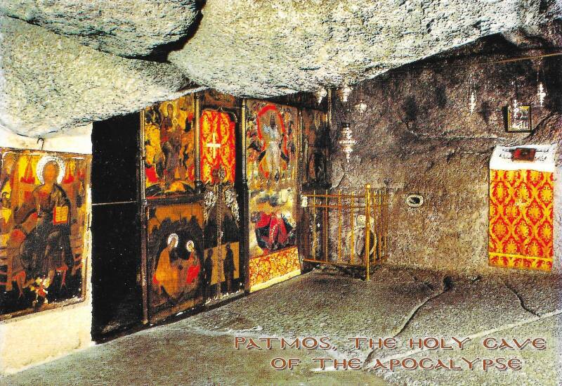
Church was built by excavating arch through tephra, hardened
layer of fine ash with lava chunks. Result is a little like
the chapel within the
Cave of the Apocalypse
on Patmos, the traditional site of John the Theologian's
visions. Maybe intentional?


Continuing Above the Chapel
alt="Cross, coast, and coastline."


Arab-Normal Fortress
ORANGE
Early Greek colony built a literal akropolis up here.
The Romans and then the Byzantines probably made
some improvements.
Fatimid Caliphate Arabs took control here in 962,
built this fortress.
Normans took it over in 1078.
YELLOW
https://www.castles.nl/taormina-castle
The construction date of Taormina Castle is unknown. Most likely, it was the site of the ancient acropolis of the Greek town of Taormina. The Romans and later the Byzantines probably strengthened the site.
The town fell to the Muslims in 902 AD, after a two-year siege. They reconstructed the castle into its current form, with a trapezoid plan adapted to the shape of the rock and crenelated walls.
In 1078, the Norman Count Roger I of Sicily, captured Taormina from the Muslims. By 1134, the castle was used by the San Salvatore la Placa monastery.
YELLOW
https://www.thatstaormina.com/item/taormina-castle/
At an elevation of about 400 meters.
Thanks to this elevated position, it is also called the Castle of the Four Panoramas, as from within its walls you can enjoy a breathtaking 360-degree view: from the Ionian coast stretching north to the Strait of Messina and south to the valley of the Alcantara River and the slopes of Mount Etna.
The fortress has a trapezoidal shape and features a tower that once served as a lookout post. The outer walls have been preserved to a height of over four meters, while the internal structures have mostly collapsed. Inside, visitors can still find a cistern used for collecting rainwater, an underground corridor for storing provisions and weapons, a fan-shaped staircase leading to the keep, and two fascinating caves to explore.


Where Next In Italy?
( 🚧 = under construction )
In the late 1990s into the early 2000s I worked on a project to
scan cuneiform tablets
to archive and share 3-D data sets,
providing enhanced visualization to assist reading them.
Localized histogram equalization
to emphasize small-scale 3-D shapes in range maps, and so on.
I worked on the project with Gordon Young,
who was Purdue University's only professor
of archaeology.
Gordon was really smart,
he could read both Sumerian and Akkadian,
and at least some of other ancient languages
written in the cuneiform script.
He told me to go to Italy,
"The further south, the better."
Gordon was right.
Yes, you will very likely arrive in Rome,
but Italy has domestic flights and a fantastic train system
that runs overnight sleepers all the way to
Palermo and Siracusa, near the western and southern corners
of Sicily.
So, these pages are grouped into a south-first order,
as they should be.