
Vulcano
Ascending the Volcano
Arrival onVulcano
The
previous page
shows the logistics of the high-speed ferry from Milazzo,
on the north coast of Sicily,
to the island of Vulcano,
along with the port town and where I stayed.
But what about the constantly venting volcano,
which has erupted violently throughout recorded history?
Its crater rim is about 270 meters above the port,
and the peak is at 386 meters.
Of course
I walked up and around the crater rim,
and continued to the peak!
This page has my pictures
and some background on the volcano itself.
The Greeks referred to the island as
"Sacred to Hephaistos" or
Ιερό
Ἥφαιστου,
Ieró Hephaistou,
because they believed that it was the chimney of the forges
of the ur-blacksmith and god of fire.
The Romans renamed Hephaestus for Spock's home planet, Vulcan,
and called this island Vulcano.
That led to "volcano" and related words
in many European languages.

Isole Eolie or the Aeolian Islands, north of Sicily. The Strait of Messina separates Sicily from Calabria, the "toe" of the Italian peninsula. Portion of aeronautical chart ONC G-2 from the Perry-Castañeda Library Map Collection at the University of Texas at Austin.
The Volcano
The Aeolian Islands rise out of the Tyrrhenian Basin, northwest of where the African Plate is sliding beneath the Eurasian Plate and forming an arc of volcanoes. The islands have formed over the past 260,000 years.
The below screenshot of an earthquake and volcano alerting smartphone app shows faults around Sicily and the volcanic Aeolian islands. Vulcano is the yellow one, indicating volcanic unrest. Lipari, to its immediate north, is green, indicating that it's dormant. Stromboli, the northernmost Aeolian island, is red, along with Etna on Sicily, indicating that it's erupting. The green one to the northwest is the Marsili seamount, a dormant submarine volcano. The dark grey ones are thought to be extinct.

Vulcano appeared above the sea about 120,000 years ago. It formed a series of calderas, in which a large magma chamber collapses, forming a relatively flat and roughly circular area surrounded by a ring shaped wall. "Caldera" comes from the same root as "cauldron", because the result resembles an enormous cooking pot. Caldera della Fossa contains the port town and the currently active cone. It formed about 24,000–15,000 years ago.
A new cone may begin forming within a cauldron when magma again begins accumulating, as has happened multiple times with the Vulcano system. The currently active cone began erupting and building up about 5,500 years ago. It is now almost 400 meters tall, with a central crater about 100 meters deep. That led the local people to call the active cone Il Fossa, meaning "The Pit".
Sakurajima Aso-san Santorini / ΘήραNow fossa is the term for a new cone formed within a caldera, as found here, Sakurajima, Aso-san, and Santorini, officially called Thira.
The below view of Vulcano from the north-northwest shows some of that geological history. The currently active cone is north of the center of the island, near the center of the roughly 4×2-km La Fossa Caldera. Beyond it in this view are eroded remnants of earlier peaks and calderas. The La Fossa Caldera is open to the sea and partially flooded, the red cargo ship is at the port town within the caldera.

Scan of a postcard showing Vulcano, looking south-southeast from above the nearby island of Lipari. A strait just 870 meters wide separates the two islands. The peninsula formed by the newer Vulcanello extends through the northern perimeter of the caldera, toward the viewpoint and to the left. Beyond the active cone and the La Fossa Caldera are the eroded remains of the older Caldera del Piano which formed about 100,000 years ago.
Vulcanello is a relatively recent 123-meter-tall composite volcanic cone structure along the northern boundary of the La Fossa Caldera. It's visible in the picture above, extending toward the viewpoint and to the left. The Greek writers Strabo (64/63 BCE – ~24 CE) and Pliny the Elder (23/24 – 79 CE). reported that Vulcanello first began erupting under the sea in 126 or 183 BCE. It didn't definitively emerge from the sea until the Middle Ages, when eruptions in 899–1044 formed the main part of its small peninsula with two cones, and then the third cone in 1400–1466. Lava flow from Vulcanello around 1550 eventually joined it to the main island as a peninsula with a narrow neck.
Multi-culturalPalermo
Muhammad al-Idrisi (1100–1165) was an Arab Muslim geographer and cartographer from North Africa, employed by King Roger II at Palermo. He created what was known in the west as the Tabula Rogeriana, one of the most advanced world atlases of the medieval era. He described Vulcano as an uninhabited island that "burns constantly day and night." More recent descriptions include:
The last 1100 years of activity of La Fossa caldera,
Vulcano Island (Italy):
new insights into stratigraphy, chronology,
and landscape evolution
Bulletin of Volcanology v86, 20 Apr 2024
https://doi.org/10.1007/s00445-024-01738-4
Growth and erosion:
The volcanic geology and morphological evolution
of La Fossa (Island of Vulcano, Southern Italy)
in the last 1000 years
Geomorphology v194, 15 Jul 2013
https://doi.org/10.1016/j.geomorph.2013.04.018
The volcanic activity changes occurred in the 2021–2022
at Vulcano island (Italy),
inferred by the abrupt variations of soil CO2 output
Scientific Reports v12, 7 Dec 2022
https://doi.org/10.1038/s41598-022-25435-4
Evolution of the Fossa Cone, Vulcano
Journal of Volcanology and Geothermal Research
v17 n1, Sep 1983
https://doi.org/10.1016/0377-0273(83)90075-6
Smithsonian Institution's Global Volcanism Program
report on Vulcano

Scan of another postcard from near the north rim of the La Fossa Caldera. Notice the steam venting from the La Fossa cone.

Amazon B0019NB9A2
There are fringe theories that Shakespeare's 1610–1611 play The Tempest was set on Vulcano, although it's obvious that Shakespeare set that play on Altair IV, the fourth planet of α Aquila. Much Ado About Nothing, Antony and Cleopatra, and The Winter's Tale were set on Sicily, the first two specifically in Messina.
The Scottish industrialist James Stevenson purchased the northern part of Vulcano after Garibaldi's "Expedition of the Thousand" overthrew Bourbon Spanish rule over Sicily in 1860. He built a villa, restarted the sulfur and alum mining operation with convicts as forced laborers, and planted vineyards.
Violent eruptions began in 1888, continuing through 1890. Meter-sized rocks and lava bombs fell across the current area of the town of Vulcano Porto, and smaller rocks and lava bombs were throw across the narrow strait onto southernmost Lipari island. Ash deposits 2–3 meters thick covered Vulcano and parts of Lipari, with 5 meters of ash remaining on the upper cone of Fossa. Stevenson sold all of his property and left the island.
Giuseppe Mercalli was an Italian geologist. He devised what we now call the Modified Mercalli Intensity or MMI scale to measure and designate the effects of an earthquake at a specific location. A magnitude scale estimates the total amount of released energy, while the MMI measures the intensity of shaking on the surface.
Mercalli came to Vulcano during its 1888–1890 eruption, its most recent of that magnitude. He made measurements and observations, describing the eruptions in great detail. That became the reference version of what we now call Vulcanian eruptions.
Visiting Rapa NuiA shield volcano emits soft liquid lava which freely flows and spreads out. The Hawaiian islands and Rapa Nui are examples of shield volcanos, as is the 600-kilometer-wide Olympus Mons on Mars. Shield volcanoes are much wider than tall, with gently sloping surfaces.
Amazon B073LZ7NZ3
Stratovolcanos are the far more exciting variety, because they tend to explode. Their lava is much more viscous, so they form much steeper cones. The lava flow can block itself, so pressure builds up until something cuts loose. A phreatic explosion happens when water flows into a magma chamber, flashes to steam, and the pressure suddenly skyrockets. The result can be an enormous explosion, like the one at Krakatoa (which is actually west of Java) in 1883 and the one at Thira around 1600 BCE. Both of those resulted in large flooded calderas, and both have one or more new fossa cones forming within their caldera.
Mercalli described the Vulcano eruption as sounding like a series of irregularly spaced cannon shots, throwing lava bombs that solidified to resemble large loaves of bread.
Since that time, activity has been limited to intense fumarole emissions from the summit of La Fossa and around the Porto di Levante harbor.
Planning My Ascent
The path up La Fossa begins where Provincial Road 179 leaves the edge of town. The authorities had placed a sign with two aerial photographs near the start of the trail.
A bright green line indicates the path. Notice how the path starts up and to the right, soon turns to the left, then to the right again for the longest roughly straight segment, and then to the left again. It then turns back to the right as it reaches the crater rim, continuing counter-clockwise around the rim to the highest point, near the top of the picture. Light yellow-green indicates areas of more intense fumarole activity.

Do not use Google Maps to plan your route! Here is an example of nonsense it suggests — the segment from the "50 min" marker to the red end point would take you through the worst of the fumaroles. Steam and hydrogen sulfide at 300 °C and hotter, you do not want to venture into that.

DO NOT USE THIS MAP FOR ROUTE PLANNING. The oligarchs and their purported "artificial intelligence" are trying to kill us.
Ascending La Fossa
Take plenty of water. Walk to the edge of town on Provincial Road 179, lined with cacti (see note re water). The start of the path will be obvious. There are signs and a signal light where the path begins.


The GO / DON'T GO signal changes based on live data from gas sensors along the crater rim. Next to the signal is the annotated aerial picture I photographed.
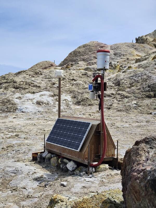
Below is one of the many solar-powered RF-linked gas sensors distributed around Vulcano. It has solar panels on both steeply sloping "roof" panels of the base, where the batteries, power management, and other subsystems reside. The pole on our right holds multiple gas sensors. The pole on the left has a microwave antenna, presumably for 5 GHz given its size, pointed just over our left shoulder.
Plants grow part-way up the cone. By the time you reach the half-way point, there's nothing but gorse and broom, and those end before you ascend much further.

The volcanic cone is formed from compacted ash and other tephra with larger lava stones within it. La Fossa erupts in a long irregular cycle. It will be active for a while, ejecting more material onto the cone and the surrounding terrain. Then it will be relatively quiet while erosion modifies the surface. Here you see the path crossing an eroded channel running down the slope.

Beyond the edge of the plant life, it's nothing but dark grey coarse basalt sand and small stones.

The bottom half of the ascent to the crater rim is the most tiring, because it's fairly steep and you're walking in coarse sand.

About two-thirds of the way to the crater rim, in terms of elevation, it transitions from dark grey coarse sand to tuff, beige compacted ash and pumice.

The view becomes more impressive as you ascend. Below is the view looking slightly west of north over Porto di Levante, the narrow strait and Lipari island, and further away to the left, Salina island.

The path becomes much easier to walk on. Or at least that was the case for me when I visited during May, a time of little rain. In the rainy season, October through January, this would be a slippery mess.

This is definitely a steep-sloped shield volcano.

The view opens up when you reach the north edge of the crater rim, about 270 meters above the port. In this view to the north-northeast, Panarea is the darker wedge-shaped island in the distance near the center of the picture. Beyond it, to its right and fainter, is Stromboli. Panarea and Stromboli are 28 and 48 kilometers away, respectively.

Turning to the left and looking north, the twin volcanic cones of Salina are almost visible through the clouds formed as air moves up and over. Salina's taller peak is at 962 meters.

The view to the northwest is over part of the eroded caldera wall that formed about 24,000–15,000 years ago.

I turned to my right to continue up and around the crater rim in a counter-clockwise direction. In the distance here you see several people in the opposite direction toward active fumaroles.

La Fossa means "The Pit". The active volcano cone is named for the inverse conical crater at its peak. This crater is about 500 meters wide and 100 meters deep. Here you see the yellow sulfur deposits created by the hydrogen sulfide and sulfur dioxide venting along with steam from a fracture zone along the rim. The steam and gases are routinely in the range of 300–430 °C. Remember, that's where Google Maps tells you to go.


Zooming in, here's a better view of the sulfur deposits and steam.

Hydrogen sulfide or H2S is a colorless, toxic, corrosive, and flammable gas with an odor of rotten eggs.
Sulfur dioxide or SO2 is a colorless gas with the odor of burnt matches. It's toxic, but much less toxic than H2S.

Carbon dioxide or CO2 is another dangerous component of the venting gases. Most of our atmosphere is nitrogen, which has a density of 1.2506 kg/m3. CO2 is much denser, at 1.977 kg/m3. Going down into a pit below several volcanic gas vents would be a very bad idea, unless you're carrying and breathing from your own clean air supply.

The path continues around the crater rim. The 386-meter peak of the La Fossa cone is the high point in the distance toward the left edge of this picture. That was my goal.


The flows of venting steam and gases fluctuate from moment to moment.

Looking back along the rim toward the northwest, some approaching clouds are about level with the crater rim.


I made it to the peak! 386 meters elevation.

The GPS receiver on my phone claimed that I was at 439 meters, 53 meters above the actual elevation. GPS is quite good for horizontal position, latitude and longitude, but it's much less accurate for elevation.

GPS accuracy is subject to errors from various sources, up to approximately:
- ±5 meters from ionospheric signal dispersion, slight delays of the 1575.42 and 1227.60 MHz signals, plus
- ±0.5 meter from tropospheric (weather) signal dispersion, plus
- ±2.5 meters from ephemeris errors, deviations of satellites from their expected paths, plus
- ±2 meters from satellite clock errors, plus
- ±4 meters from receiver clock errors, plus
- ±1 meter from multipath signal errors
That combines into an error of up to 15 meters in horizontal position. Because elevation measurement can only use satellites above the receiver position, the vertical error is two to three times larger, or 30–45 meters. Further issues including local deviation from the reference geoid add to that error. GPS location accuracy is a bottomless rabbit hole of detail.
Added to all that is the fact that I'm standing on a volcano which swells because of the pressure of the gases dissolved in the magma and erodes rapidly when it rains.

The bases of some clouds passing over the crater were lower than the peak.

The first recorded ascent of La Fossa occurred in the late 13th century. The Dominican friar Burchard of Mount Sion traveled to Jerusalem and documented his journey in his book Descriptio Terrae Sanctae or "Description of the Holy Land". He stopped in Sicily on his way home to northern Germany around 1284, and wrote that he climbed to the summit of Vulcano "crawling on his hands and feet".

It is much easier to ascend today, with a well-established trail switching back and forth across the steep slope. No crawling required.


After a while I headed back down the way I had come.


Having returned to where the crater rim paths diverge, I continued a short distance clockwise around the crater rim toward the steam and gas vents.

You can see a square platform along the crater rim, near the left edge of this picture where some people are standing. It's a helicopter landing pad, built so the authorities can airlift celebrities in and victims out.

I sat on the edge of the helipad and watched the steam and gas venting rapidly change.


Then, I headed back down the volcano.
The high-altitude mountaineer Ed Viesturs is the only American to have climbed all fourteen of the world's 8,000-meter mountains, and was the fifth person to do so without using supplemental oxygen. He is famous for having written, "Getting to the top is optional. Getting down is mandatory."
Be like Ed. Don't go up anything unless you're certain that you can safely descend. Going down is always harder than going up.
I mentioned that the bottom half to two thirds of the path was the most tiring, because you walk through coarse sand. It seemed much worse going down. My haunches and lower back were sore later.

I stumbled off the bottom end of the path, where a middle-aged German couple was sitting in the shade under a tree. She spoke English and began quizzing me about how far I had been. All the way — up to the crater rim, around that, and up to the peak. She wrinkled her nose and made a dismissing gesture at my feet, clad in cheap sandals manufactured in a Chinese forced-labor factory contracted by Sam Walton's family. "We would not think you could go there in such... footwear." Well, it's not as if I was dancing through the steaming fumaroles. Neither should anyone else, even if they're wearing Tuetonically approved footwear.
From Vulcano I continued by ferry to Stromboli.
Where Next In Italy?
( 🚧 = under construction )
In the late 1990s into the early 2000s I worked on a project to
scan cuneiform tablets
to archive and share 3-D data sets,
providing enhanced visualization to assist reading them.
Localized histogram equalization
to emphasize small-scale 3-D shapes in range maps, and so on.
I worked on the project with Gordon Young,
who was Purdue University's only professor
of archaeology.
Gordon was really smart,
he could read both Sumerian and Akkadian,
and at least some of other ancient languages
written in the cuneiform script.
He told me to go to Italy,
"The further south, the better."
Gordon was right.
Yes, you will very likely arrive in Rome,
but Italy has domestic flights and a fantastic train system
that runs overnight sleepers all the way to
Palermo and Siracusa, near the western and southern corners
of Sicily.
So, these pages are grouped into a south-first order,
as they should be.